Monday: Sun and clouds, with highs near 50°
Tuesday: Sun and clouds, with highs near 50°
Wednesday: Sun and clouds, with highs in the mid-50's
Thursday: Cloudy, with a chance of showers and highs in the upper-50's
Friday: Rain, with a high near 50°
Monday, December 2, 2013
Monday, November 25, 2013
Thanksgiving-Eve Storm
Overview
As most everybody has probably heard by now, we have a strong storm heading up the east coast tomorrow (11/26), and lasting through the day on Wednesday. Originally, at the beginning of last week, model runs were showing a possible snowstorm. Unfortunately, as the days went on, that threat went away and a rainstorm is what is left for South Jersey and Philadelphia.

Timing
Some scattered showers and rain out ahead of the system may start affecting us tomorrow afternoon, but the main bulk of the rain should arrive in the evening, around 5-8PM. This rain will be heavy and persistent, as it will last into the day on Wednesday. As the precipitation begins to taper off in the later afternoon/evening, the rain may mix in with some snow or changeover to some light flurries/snow showers toward the end of the storm, as cold air begins to wrap around the low into our area.
How Much?
Right now, it appears like this system will be a soaker, bringing 2-4 inches of rain to the region, with more possible in localized areas. Any flurries, if a changeover occurs at all, will almost certainly not accumulate into anything. The only areas that will experience snow are the Poconos and interior portions of Pennsylvania, well west of Philadelphia. At the bottom of the post is a QPF (Quantitative Precipitation Forecast) map from the National Weather Service, which shows a model forecast for liquid precipitation amounts.
Other Effects
Of course, the main concern with this storm is the impact that it will have on travel during one of the biggest travel time periods of the year. Anywhere from the Gulf Coast to Maine will see severe travel problems due to rain, wind, and snow. Locally, other than rain, we could see wind gusts up to 30mph and some tidal flooding. Temperatures tomorrow will be one of those abnormal times when temperatures increase throughout the night. We will see mid-40's during the day, tomorrow, that will increase into the 50's during the night, giving us highs in the mid-50's on Wednesday. Then, as the storm moves through, cold air will plunge in, bringing highs into the 30's on Thursday and Friday.

11/25 7PM Radar (with added details)

Source: http://synoptic.envsci.rutgers.edu/site/radar.php?&conus=anim&radar=CONUS
QPF Forecast (11/26 0Z-11/29 0Z)

Source: http://www.hpc.ncep.noaa.gov/qpf/d13_fill.gif
Wednesday, November 20, 2013
Winter Temperatures Coming: 5-Day Forecast
Thursday: Sun and clouds; highs of around 50°
Friday: Sun and clouds, with showers late; highs in the mid-50's
Saturday: Scattered showers, clearing to sun and clouds; highs in the mid-50's
Sunday: Sun and clouds, with a chance of flurries; highs in the mid-30's
Monday: Sunny; highs in the upper-30's
Monday, November 11, 2013
Chilly 5-Day Forecast
Tuesday: Rain/snow showers and clouds clearing throughout the day, temperatures around 40°
Wednesday: Sunny, with highs in the mid-40's
Thursday: Sunny, with highs in the lower-50's
Friday: Sunny, with highs in the mid-50's
Saturday: Sun and clouds, with highs near 60°
Wednesday: Sunny, with highs in the mid-40's
Thursday: Sunny, with highs in the lower-50's
Friday: Sunny, with highs in the mid-50's
Saturday: Sun and clouds, with highs near 60°
Tuesday, October 29, 2013
Rain Leads to a Sunny Weekend: 5-Day Forecast
Wednesday: Sun and clouds, with a chance of showers; highs in the mid-60's
Thursday: Sun and clouds, with a chance of showers; highs in the upper-60's
Friday: Showers; highs around 70°
Saturday: Sunny; highs in the mid-60's
Sunday: Sunny; highs near 60°
Wednesday, October 23, 2013
Beautiful, Yet Chilly 5-Day Forecast
Thursday: Sunny; highs in the mid-50's
Friday: Sunny; highs in the mid-50's
Saturday: Sunny; highs in the mid-50's
Sunday: Sun and clouds; highs in the mid-50's
Monday: Sunny; highs in the mid-50's
Get ready for overnight lows to get into the 30's or near 40° over the next several days and also be on the lookout for frost if you're up early in the morning!
Tuesday, October 15, 2013
5-Day Forecast
Wednesday: Cloudy, with a chance of showers; highs near 70°
Thursday: Sun and clouds, with highs in the mid-70's
Friday: Sunny, with a chance of showers early; highs near 70°
Saturday: Sun and clouds; highs in the mid-60's
Sunday: Sunny; highs near 70°
Thursday: Sun and clouds, with highs in the mid-70's
Friday: Sunny, with a chance of showers early; highs near 70°
Saturday: Sun and clouds; highs in the mid-60's
Sunday: Sunny; highs near 70°
Thursday, October 10, 2013
5-Day Forecast: Dreary End to the Week
Friday: Periods of rain and breezy; highs in the mid-60's
Saturday: Cloudy and breezy, with scattered rain; highs near 70°
Sunday: Cloudy, with a chance of rain; highs in the mid-60's
Monday: Sun and clouds; highs in the mid-60's
Tuesday: Sunny; highs near 70°
Saturday: Cloudy and breezy, with scattered rain; highs near 70°
Sunday: Cloudy, with a chance of rain; highs in the mid-60's
Monday: Sun and clouds; highs in the mid-60's
Tuesday: Sunny; highs near 70°
Sunday, October 6, 2013
Storm Update
Well, Karen has dissipated in the Gulf of Mexico before even making a landfall...however, her remnants will become absorbed into the cold front that is moving through tomorrow.
Timing
Scattered showers are possible tomorrow morning into the afternoon, out ahead of the front. The main line of rain and storms is expected to pass through in the late afternoon/evening and last until around midnight. We should wake up to sun and clouds on Tuesday, though!
Effects
-Expect .5-2 inches of rain across the area, with some places possibly receiving more
-Winds up to 20-25mph
-Wave heights up to 6 to 7 feet
-Localized minor flooding due to quick/heavy rainfall on dry land
Friday, October 4, 2013
Effects of Tropical Storm Karen
Current Information (2pm EDT Advisory)
Max Winds: 50mph
Minimum Pressure: 1003mb
Moving NNW at 9mph
Current Forecast Track

Source: http://www.nhc.noaa.gov/graphics_at2.shtml?gm_track#contents
7-Day Precipitation Forecast

The above maps show both the track and the 7-day precipitation forecast from today, October 4th, until October 11th, which encompasses the time in which Tropical Storm Karen's remnants will affect southern New Jersey. Now, not only will we be dealing with Karen's remnants, but the current winter storm in the northern Plains and Northwestern US will be moving across the nation as the cold front associated with it will move through New Jersey around the same time as the tropical storm's remnants. Below, I will explain what each of the main models is saying. Finally, the last section will include what to expect, as of now, with regards to how much rain and any other effects, like winds and wave heights.
GFS
The GFS's latest run from this afternoon currently has Karen moving northward toward Louisiana before hooking to the east, moving along the Gulf Coast, and then making a main landfall in the Florida panhandle. From there, Karen will then essentially meet up with the cold front, as she becomes extratropical and blends into the front. All together, this run has the precipitation beginning on Monday night and lasting into Tuesday evening, before clearing out.
EURO
The European model run shows a less intense storm as it makes landfall along the Gulf Coast, with less moisture and higher pressure. The storm then takes roughly the same trek, as described in the paragraph above, but the timing is a little later and provides less precipitation for our area. The timing would be early Tuesday morning into Tuesday night.
Summary
All together, we are looking at a decent soaking from the combination of the cold front and remnants of Tropical Storm Karen. Timing-wise, expect scattered showers to move in on Monday out ahead of the storms, with the main bulk of rain occurring between Monday night and Tuesday afternoon. The chance of showers should dwindle as the evening/night progresses on Tuesday. Rainfall amounts, naturally, will vary from location to location, but 1"-3" of rain should be expected at this time, with totals on either side of that range still being possible. Finallly, though the rain should be the worst of it, sustained wind speeds are forecasted at 14-20mph, with gusts up to 30-35mph, and winds will be faster down the shore as there is no friction coming off the ocean to slow the flow of air. Then, wave heights are currently forecasted to be in the 4-7 ft. range. We are still 72-84 hours out, so if anything changes, I will post an update. If I had to guess how the forecast would change if it did, I would say that the storm, in general, would come in less intense, but time will tell.
Max Winds: 50mph
Minimum Pressure: 1003mb
Moving NNW at 9mph
Current Forecast Track

Source: http://www.nhc.noaa.gov/graphics_at2.shtml?gm_track#contents
7-Day Precipitation Forecast

Source: http://www.hpc.ncep.noaa.gov/qpf/p168i.gif
GFS
The GFS's latest run from this afternoon currently has Karen moving northward toward Louisiana before hooking to the east, moving along the Gulf Coast, and then making a main landfall in the Florida panhandle. From there, Karen will then essentially meet up with the cold front, as she becomes extratropical and blends into the front. All together, this run has the precipitation beginning on Monday night and lasting into Tuesday evening, before clearing out.
EURO
The European model run shows a less intense storm as it makes landfall along the Gulf Coast, with less moisture and higher pressure. The storm then takes roughly the same trek, as described in the paragraph above, but the timing is a little later and provides less precipitation for our area. The timing would be early Tuesday morning into Tuesday night.
Summary
All together, we are looking at a decent soaking from the combination of the cold front and remnants of Tropical Storm Karen. Timing-wise, expect scattered showers to move in on Monday out ahead of the storms, with the main bulk of rain occurring between Monday night and Tuesday afternoon. The chance of showers should dwindle as the evening/night progresses on Tuesday. Rainfall amounts, naturally, will vary from location to location, but 1"-3" of rain should be expected at this time, with totals on either side of that range still being possible. Finallly, though the rain should be the worst of it, sustained wind speeds are forecasted at 14-20mph, with gusts up to 30-35mph, and winds will be faster down the shore as there is no friction coming off the ocean to slow the flow of air. Then, wave heights are currently forecasted to be in the 4-7 ft. range. We are still 72-84 hours out, so if anything changes, I will post an update. If I had to guess how the forecast would change if it did, I would say that the storm, in general, would come in less intense, but time will tell.
Tuesday, October 1, 2013
Beautiful 5-Day Forecast: Mini Heat Wave
Wednesday: Sunny; highs in the mid-80's
Thursday: Sun and clouds; highs around 80°
Friday: Sun and clouds, with a chance of storms/showers; highs in the 80's
Saturday: Sun and clouds; high around 80°
Sunday: Sun and clouds; highs around 80°
Thursday: Sun and clouds; highs around 80°
Friday: Sun and clouds, with a chance of storms/showers; highs in the 80's
Saturday: Sun and clouds; high around 80°
Sunday: Sun and clouds; highs around 80°
Thursday, September 26, 2013
Another Beautiful 5-Day Forecast
Thursday: Sun and clouds; highs in the mid-70's
Friday: Sun and clouds; highs in the mid-70's
Saturday: Sunny; highs in the lower-70's
Sunday: Sunny; highs in the lower-70's
Monday: Sun and clouds; highs in the mid-70's
Friday: Sun and clouds; highs in the mid-70's
Saturday: Sunny; highs in the lower-70's
Sunday: Sunny; highs in the lower-70's
Monday: Sun and clouds; highs in the mid-70's
Saturday, September 21, 2013
5-Day Forecast: Stormy Saturday Night to Beautiful Conditions
Saturday: Increasing clouds throughout day, showers and storms mainly toward nightfall; highs near 80°
Sunday: Clearing to sunny conditions; highs in the 70°
Monday: Sunny; highs around 70°
Tuesday: Sunny; highs in the lower-70's
Wednesday: Sun and clouds; highs in the 70's
Sunday: Clearing to sunny conditions; highs in the 70°
Monday: Sunny; highs around 70°
Tuesday: Sunny; highs in the lower-70's
Wednesday: Sun and clouds; highs in the 70's
Sunday, September 15, 2013
5-Day Forecast: More Beautiful Weather This Week
Monday: Sun and clouds, with a chance of scattered showers; highs around 70°
Tuesday: Sunny; highs near 70°
Wednesday: Sunny; highs in the mid-70's
Thursday: Sunny; highs near 80°
Friday: Sunny; highs around 80°
Tuesday: Sunny; highs near 70°
Wednesday: Sunny; highs in the mid-70's
Thursday: Sunny; highs near 80°
Friday: Sunny; highs around 80°
Tuesday, September 10, 2013
5-Day Forecast: Heat Wave, Then a Cooldown
Wednesday: Sunny, with showers toward nightfall; highs around 90°
Thursday: Sun and clouds, with a chance of showers/storms; highs near 90°
Friday: Sunny, with a chance of an early shower; highs around 70°
Saturday: Sunny; highs near 70°
Sunday: Sunny; highs around 70°
Thursday: Sun and clouds, with a chance of showers/storms; highs near 90°
Friday: Sunny, with a chance of an early shower; highs around 70°
Saturday: Sunny; highs near 70°
Sunday: Sunny; highs around 70°
Wednesday, September 4, 2013
Sunny, September 5-Day Forecast
Wednesday: Sunny; highs in the lower-80's
Thursday: Sunny; highs in the mid-80's
Friday: Sunny; highs in the upper-70's
Saturday: Sunny; highs around 80°
Sunday: Sun and clouds, with a chance of showers and storms; highs in the lower-80's
Thursday: Sunny; highs in the mid-80's
Friday: Sunny; highs in the upper-70's
Saturday: Sunny; highs around 80°
Sunday: Sun and clouds, with a chance of showers and storms; highs in the lower-80's
Thursday, August 29, 2013
5-Day Forecast
Friday: Sun and clouds; highs in the 80's
Saturday: Sun and clouds, with a chance of rain; highs in the 80's
Sunday: Sun and clouds, with a chance of rain; highs in the 80's
Monday: Sun and clouds, with a chance of rain; highs in the 80's
Tuesday: Sun and clouds, with a chance of rain; highs around 80°
Saturday: Sun and clouds, with a chance of rain; highs in the 80's
Sunday: Sun and clouds, with a chance of rain; highs in the 80's
Monday: Sun and clouds, with a chance of rain; highs in the 80's
Tuesday: Sun and clouds, with a chance of rain; highs around 80°
Friday, August 23, 2013
Beautiful Weekend Ahead: 5-Day Forecast
Saturday: Sunny; highs around 80°
Sunday: Sunny; highs in the 80's
Monday: Sunny; highs in the 80's
Tuesday: Sun and clouds, chance of rain/storms; highs in the 80's
Wednesday: Sun and clouds, chance of rain/storms; highs in the 80's
Sunday: Sunny; highs in the 80's
Monday: Sunny; highs in the 80's
Tuesday: Sun and clouds, chance of rain/storms; highs in the 80's
Wednesday: Sun and clouds, chance of rain/storms; highs in the 80's
Sunday, August 18, 2013
Beautiful Warm-Up: 5-Day Forecast
Monday: Cloudy, with some sun, chance of showers; highs around 80°
Tuesday: Sunny; highs near 90°
Wednesday: Sunny; highs near 90°
Thursday: Sunny, with a chance of showers; highs near 90°
Friday: Sun and clouds; highs near 90°
Tuesday: Sunny; highs near 90°
Wednesday: Sunny; highs near 90°
Thursday: Sunny, with a chance of showers; highs near 90°
Friday: Sun and clouds; highs near 90°
Wednesday, August 14, 2013
B-e-a-utiful 5-Day Forecast
The passage of a cold front on Tuesday will usher in high pressure. This area of high pressure will provide below-average temperatures and plenty of sun!
Wednesday: Sunny; highs around 80°
Thursday: Sunny; highs around 80°
Friday: Sunny; highs in the 80's
Saturday: Sun and clouds; highs in the 80's
Sunday: Sun and clouds; highs around 80°
Furthermore, New Jersey's second tornado of the year(we average 3 per year) touched down on the morning of Tuesday, August 13th around 10:05am near Manahawkin, NJ. It was an EF0, with estimated winds of 75-85mph, a path width of 50-100 yards, and a path length of 2 miles. Fortunately, there were no fatalities or injuries, and the damage extended to downed trees and damaged roofs.
Finally, outside of New Jersey, the Atlantic Hurricane Season is heading toward its peak, it seems to be heating up. Two areas are under investigation: Invest 92 and Invest 93. Invest 92 is located in the Caribbean Sea and currently has a moderate chance(30%) of becoming a tropical system in the next 48 hours. Invest 93 is located off the coast of Africa, with a moderate chance(40%) of development into a tropical system within the next 48 hours.
Friday, August 9, 2013
Great 5-Day Forecast
Friday: Cloudy with peaks of sunshine, scattered rain/storms; highs in the 80's
Saturday: Sun and clouds; highs near 90°
Sunday: Sunny; highs in the 80's
Monday: Sunny; highs in the 80's
Tuesday: Sun and clouds, chance of scattered showers; highs in the 80's
Saturday: Sun and clouds; highs near 90°
Sunday: Sunny; highs in the 80's
Monday: Sunny; highs in the 80's
Tuesday: Sun and clouds, chance of scattered showers; highs in the 80's
Saturday, August 3, 2013
5-Day Forecast
Sunday: Sunny; highs around 80°
Monday: Sunny; highs around 80°
Tuesday: Sunny and a chance of showers/storms; highs around 80°
Wednesday: Sun and clouds, with a chance of showers/storms; highs near 80°
Thursday: Sun and clouds, with a chance of showers/storms; highs in the 80's
Monday: Sunny; highs around 80°
Tuesday: Sunny and a chance of showers/storms; highs around 80°
Wednesday: Sun and clouds, with a chance of showers/storms; highs near 80°
Thursday: Sun and clouds, with a chance of showers/storms; highs in the 80's
Tuesday, July 30, 2013
Beautiful 5-Day Forecast
Tuesday: Sunny; highs in the mid-80's
Wednesday: Sunny; highs in the mid-80's
Thursday: Generally overcast, with showers and storms; highs around 80°
Friday: Sunny; highs in the mid-80's
Saturday: Sunny; highs in the mid-80's
Wednesday: Sunny; highs in the mid-80's
Thursday: Generally overcast, with showers and storms; highs around 80°
Friday: Sunny; highs in the mid-80's
Saturday: Sunny; highs in the mid-80's
Wednesday, July 24, 2013
5-Day Forecast
Thursday: Sun and clouds; highs near 80°
Friday: Sunny; highs in the 80's
Saturday: Sun and clouds, chance of showers/storms; highs in the 80's
Sunday: Showers and storms; highs in the 80's
Monday: Sunny; highs in the 80's
Friday: Sunny; highs in the 80's
Saturday: Sun and clouds, chance of showers/storms; highs in the 80's
Sunday: Showers and storms; highs in the 80's
Monday: Sunny; highs in the 80's
Saturday, July 20, 2013
Cooler 5-Day Forecast
Saturday: Last day of the heat wave as a cold front pushes through; sun and clouds, good chance of storms, some severe; highs in the 90's
Sunday: Sun and clouds; highs near 90°
Monday: Sun and clouds, chance of rain/storms; highs in the 80's
Tuesday: Sun and clouds, chance storms; highs in the 80's
Wednesday: Sun and clouds, chance storms; highs in the 80's
Sunday: Sun and clouds; highs near 90°
Monday: Sun and clouds, chance of rain/storms; highs in the 80's
Tuesday: Sun and clouds, chance storms; highs in the 80's
Wednesday: Sun and clouds, chance storms; highs in the 80's
Monday, July 15, 2013
Another Heat Wave: 5-Day Forecast
Monday: Sunny, chance of isolated showers/storms; highs in the 90's and heat indices around 100°
Tuesday: Sunny; highs in the 90's
Wednesday: Sunny; highs in the 90's
Thursday: Sunny; highs in the 90's
Friday: Sun and clouds; highs in the 90's
Tuesday: Sunny; highs in the 90's
Wednesday: Sunny; highs in the 90's
Thursday: Sunny; highs in the 90's
Friday: Sun and clouds; highs in the 90's
Tuesday, July 9, 2013
5-Day Forecast
Wednesday: Sun and clouds, chance of thunderstorms; highs near 90°
Thursday: Cloudy with peaks of sunshine, chance of thunderstorms; highs in the 80's
Friday: Sun and clouds; highs in the 80's
Saturday: Sunny; highs in the 80's
Sunday: Sun and clouds, chance of rain; highs in the 80's
Thursday: Cloudy with peaks of sunshine, chance of thunderstorms; highs in the 80's
Friday: Sun and clouds; highs in the 80's
Saturday: Sunny; highs in the 80's
Sunday: Sun and clouds, chance of rain; highs in the 80's
Friday, July 5, 2013
Heat Wave Incoming: 5-Day Forecast
Friday: Sunny; highs in the lower 90's
Saturday: Sunny; highs in the lower 90's
Sunday: Sunny with a chance of thunderstorms; highs in the lower 90's
Monday: Sun and clouds; highs near 90°
Tuesday: Sun and clouds, chance of thunderstorms; highs in the lower-90's
Saturday: Sunny; highs in the lower 90's
Sunday: Sunny with a chance of thunderstorms; highs in the lower 90's
Monday: Sun and clouds; highs near 90°
Tuesday: Sun and clouds, chance of thunderstorms; highs in the lower-90's
Saturday, June 29, 2013
More Rain Coming: 5-Day Forecast
Sunday: Sun and clouds, scattered rain and thunderstorms; highs around 80°
Monday: Thunderstorms and rain, up to a few inches, locally, is possible; highs in the 80's
Tuesday: Sun and clouds; scattered rain and thunderstorms; highs around 80°
Wednesday: Sun and clouds; scattered rain and thunderstorms; highs in the 80's
Thursday, 4th of July: Sun and clouds, scattered rain and thunderstorms; highs near 90°
Sunday

Sun and clouds, scattered rain and thunderstorms; highs around 80°
Monday

Thunderstorms and rain; highs in the 80's
Monday, June 24, 2013
5-Day Forecast: Heat Wave Continues
Tuesday: Mostly sunny; highs in the 90's
Wednesday: Sun and clouds, scattered thunderstorms; highs in the 90's
Thursday: Sun and clouds, scattered thunderstorms; highs around 90°
Friday: Sun and clouds, scattered thunderstorms; highs in the 80's
Saturday: Sun and clouds, scattered thunderstorms, highs in the 80's


Wednesday: Sun and clouds, scattered thunderstorms; highs in the 90's
Thursday: Sun and clouds, scattered thunderstorms; highs around 90°
Friday: Sun and clouds, scattered thunderstorms; highs in the 80's
Saturday: Sun and clouds, scattered thunderstorms, highs in the 80's
Tuesday

Mostly sunny; highs in the 90's
Wednesday

Sun and clouds, scattered thunderstorms; highs in the 90's
Thursday

Sun and clouds, scattered thunderstorms; highs around 90°
Thursday, June 20, 2013
Summer Temperatures Coming: 5-Day Forecast
Thursday: Sunny; highs in the lower-80's
Friday: Sun and clouds; highs in the mid-80's
Saturday: Sun and clouds; highs near 90°
Sunday: Sun and clouds, chance of thunderstorms; highs near 90°
Monday: Sun and clouds, chance of thunderstorms; highs near 90°
Friday: Sun and clouds; highs in the mid-80's
Saturday: Sun and clouds; highs near 90°
Sunday: Sun and clouds, chance of thunderstorms; highs near 90°
Monday: Sun and clouds, chance of thunderstorms; highs near 90°
Friday, June 14, 2013
Beautiful Weekend Forecast
Saturday: Sunny; highs near 80°
Sunday: Sun and clouds, scattered thunderstorms; highs in the lower-80's
Monday: Sun and clouds, scattered thunderstorms; highs in the 80's

Sunday


Sunday: Sun and clouds, scattered thunderstorms; highs in the lower-80's
Monday: Sun and clouds, scattered thunderstorms; highs in the 80's
Saturday

Sunny; highs near 80°

Sun and clouds, scattered thunderstorms; highs in the lower-80's
Monday

Sun and clouds, scattered thunderstorms; highs in the 80's
Wednesday, June 12, 2013
Severe 3-Day Forecast
Wednesday: Sun and clouds; highs around 80°
Thursday: Rain and thunderstorms, some may be severe with the possibility of severe wind gusts, hail, and flooding; highs in the 70's
Friday: Sun and clouds with a chance of storms; highs in the lower-70's


Thursday: Rain and thunderstorms, some may be severe with the possibility of severe wind gusts, hail, and flooding; highs in the 70's
Friday: Sun and clouds with a chance of storms; highs in the lower-70's
Wednesday

Sun and clouds; highs around 80°
Thursday

Rain and thunderstorms, some may be severe with severe wind gusts; highs in the 70's
Friday

Sun and clouds with a chance of storms; highs in the lower-70's
Saturday, June 8, 2013
3-Day Forecast
*Couldn't get visuals up today*
Sunday: Sunny; highs in the mid-80's
Monday: Sun and clouds, chance of a scattered thunderstorm; highs in the upper-70's
Tuesday: Sun and clouds, chance of a scattered thunderstorm; highs around 80°
Andrea Storm Precipitation Totals Report
Tropical Storm Andrea has left our area but not before dumping a copious amount of rain on our area. The center of the storm moved right along the New Jersey coastline while exiting. The following are some rainfall amounts from the National Weather Service in Mt. Holly:
Mt. Laurel: 5.50"
Glassboro: 4 .45"
New Brunswick: 4.01"
Philadelphia Int'l: 3.82"
Moorestown: 3.70"
Seaside Heights: 3.52"
Sewell: 3.46"
Burlington: 3.42"
Atlantic City: 2.92"
Collingswood: 2.77"
Millville: 2.27"
*For a complete list, go to: http://forecast.weather.gov/product.php?site=NWS&issuedby=PHI&product=PNS&format=CI&version=1&glossary=0
Thursday, June 6, 2013
Tropical Storm Andrea Update #2
Tropical Storm Andrea made landfall in Dixie County, Florida this evening. As of 5pm, the storm was around 856 miles southwest of Philadelphia with winds of 65mph, an air pressure of 993mb, and moving northeast at 17mph. Andrea is still forecasted to track up the Atlantic seaboard and move over New Jersey on Friday. It will bring up to a couple inches of rain to our area with locally higher amounts of precipitations, which gives us the threat of flooding. Furthermore, there will be some gusty winds, mainly along the shore points, and the risk of storm surge and wave heights will be low.
NWS Projected Path

Credit: http://www.nhc.noaa.gov/graphics_at1.shtml?5-daynl?large#contents
Current Location

Credit: https://maps.google.com/maps?hl=en&tab=wl
Wednesday, June 5, 2013
3-Day Forecast and Tropical Storm Andrea Forms
Thursday

Sun and clouds; highs in the 70's
Friday

Rain; highs in the 70's
Saturday

Lingering showers and storms to some sun; highs around 80°
*Posted are the 2PM temperatures, the precipitation amounts from 24 hours prior, and the 8PM air pressure*
First Tropical System of the Season
Tropical Storm Andrea has formed in the Gulf of Mexico just a few days after the start of the hurricane season, which ranges from June 1st to November 30th. Andrea is a weak tropical storm with 40mph winds and an air pressure of 1002mb. It is slowly drifting north at 3mph and is located around 1,205 miles southeast of Philadelphia. Over the next few days, Andrea is forecasted to move toward the northeast along the Atlantic coast and bring up to a couple inches of rain and some gusty winds to New Jersey for Friday into early Saturday morning.
National Weather Service Projected Path

Credit: http://www.nhc.noaa.gov/graphics_at1.shtml?5-daynl#contents
Projected Rainfall Between Wednesday and Saturday Evening

Credit: NOAA
Sunday, June 2, 2013
Heat Wave Breaks
Monday

Showers and scattered storms; highs in the 70's
Tuesday

Sunny; highs in the 70's
Wednesday

Sun and clouds; highs in the 70's
*2 PM temperatures on the left and 8 AM to 8 PM rainfall on the right with air pressure*
Thursday, May 30, 2013
Heat Wave Continues
Friday

Sunny; highs around 90°
Saturday

Sun and clouds; highs around 90°
Sunday

Sun and clouds with a chance of storms; highs in the 80's
*2 PM Temperatures and Precipitation Amounts from 8 AM to 8 PM with Air Pressure*
Monday, May 27, 2013
Heat Wave Incoming
Tuesday

Showers, maybe with a few rumbles of thunder; highs around 70°
Wednesday

Clouds and sun; highs in the 80's
Thursday

Sunny; highs around 90°

Showers, maybe with a few rumbles of thunder; highs around 70°
Wednesday

Clouds and sun; highs in the 80's
Thursday

Sunny; highs around 90°
Friday, May 24, 2013
Memorial Day Weekend Forecast
Saturday

Showers tapering off in the morning, windy; highs in the 60's
Sunday
Sunny; highs near 70°
Monday

Partly Cloudy; highs in the 70's

Showers tapering off in the morning, windy; highs in the 60's

Sunday
Sunny; highs near 70°
Monday

Partly Cloudy; highs in the 70's
Tuesday, May 21, 2013
New Forecast Visuals
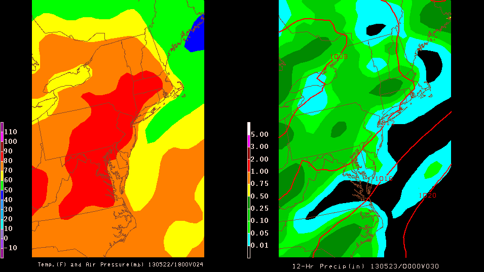
I'm going to start a new way of doing forecasts now that I have more time at home for the Summer. I'll be using a program called 'GEMPAK' that allows me to create my own weather maps, so it will give a visual way of presenting forecasts instead of just text. I'll give maps out to three days using the NAM model, which is a short-range model, and these map will give temperatures and air pressure for 2pm, and precipitation totals from 8am to 8pm for each day. I will also post maps and text updates of severe weather when necessary. I'm hoping to start this by the weekend.

Here is an early example for tomorrow, Wednesday, May22nd:
Monday, May 20, 2013
5-Day Forecast
Monday: Clouds and sun; highs around 80°
Tuesday: Cloudy; highs in the mid-80's
Wednesday: Clouds and sun; highs in the upper-80's
Thursday: Scattered thunderstorms; highs around 80°
Friday: Showers; highs in the lower-70's
Tuesday: Cloudy; highs in the mid-80's
Wednesday: Clouds and sun; highs in the upper-80's
Thursday: Scattered thunderstorms; highs around 80°
Friday: Showers; highs in the lower-70's
Tuesday, May 14, 2013
Beautiful 5-Day Forecast
Wednesday: Sun and clouds, chance of evening storms; highs in the mid-70's
Thursday: Partly Cloudy; highs around 80°
Friday: Sun, with some clouds; highs in the upper-70's
Saturday: Sun and clouds; highs in the lower-70's
Sunday: Showers; highs in the lower-70's
Thursday: Partly Cloudy; highs around 80°
Friday: Sun, with some clouds; highs in the upper-70's
Saturday: Sun and clouds; highs in the lower-70's
Sunday: Showers; highs in the lower-70's
Sunday, May 12, 2013
General Weather Misconceptions
Monsoon
This one is one of the most popular misconceptions that I have heard growing up, and it is that people associate a heavy rain event with being a monsoon. Yes, a monsoon is the cause of an intense rainy season and can bring a lot of rain, but it also leads to a dry season as well. Simply put, a monsoon is a seasonal reversal of the wind pattern that is accompanied by changes in precipitation and winds.
Essentially, a monsoon is caused by the difference in heating of land and water surfaces at different times of the year because each surface absorbs heat differently. The water absorbs a lot more heat in order for it to change temperature, whereas the land takes less heat to change the temperature. Therefore, during the warm months, the land heats up quicker than the sea causing the atmospheric gases to expand there providing lower pressure over land and higher pressure over the water. This then results in moist air flowing from the sea to the land, called a sea breeze, and the air then rises and condenses to bring large amounts of precipitation in the 'rainy season'.
The opposite occurs in the colder months when the lands cools faster than the sea. Here, low pressure occurs over the water due to it being warmer, and air flows from the high pressure over land to the sea, called a land breeze. Dry conditions then occur over land and precipitation falls over the water, which is why it is called the 'dry season' on land.
This process is what is seen along the New Jersey shore but to a smaller and less intense scale.

Lightning
Contrary to what is commonly believed, lightning can in fact strike the same place more than once and also does not always strike the ground
First, lightning is an electrical discharge when there is a buildup of opposite electrical charges, and lightning is what occurs as the process that tries to make the electrical distribution equal. To get onto the misconception, lightning can strike the same place, or human for that matter, more than once. That is because electrical charges do not have a memory and can not know where a lightning strike has occurred before.
Furthermore, lightning does necessarily have to strike the ground. Differences in electrical charge can form within a cloud, between two different clouds, between a cloud and the air, or between the cloud and the surface. Therefore, you can have four different types of lightning: intra-cloud(within a cloud), cloud-to-cloud lightning, cloud-to-air lightning, and cloud-to-ground lightning.
Finally, the method to tell how far away a storm is from you is called the 'flash bang method'. Count the number of seconds between the lightning flash and thunder, then divide by five, and that is how many miles the storm is from your location.
Thursday, May 9, 2013
5-Day Forecast
Friday: Partly cloudy, scattered storms late; highs in the mid-80's
Saturday: Scattered showers and storms; highs in the upper-70's
Sunday: Partly cloudy; highs in the upper-60's
Monday: Partly cloudy; highs around 60°
Tuesday: Partly cloudy; highs in the mid-60's
Saturday: Scattered showers and storms; highs in the upper-70's
Sunday: Partly cloudy; highs in the upper-60's
Monday: Partly cloudy; highs around 60°
Tuesday: Partly cloudy; highs in the mid-60's
Thursday, May 2, 2013
Beautiful 5-Day Forecast
Friday: Sunny; highs in the mid-60's
Saturday: Sun with a few clouds; highs around 70°
Sunday: Partly cloudy; highs in the mid-60's
Monday: Sun and clouds; highs around 70°
Tuesday: Light showers; highs around 70°
Saturday: Sun with a few clouds; highs around 70°
Sunday: Partly cloudy; highs in the mid-60's
Monday: Sun and clouds; highs around 70°
Tuesday: Light showers; highs around 70°
Sunday, April 28, 2013
5-Day Forecast
Sunday: Partly cloudy; highs in the the lower-70's
Monday: Showers later in the day; highs in the lower-60's
Tuesday: Rain showers; highs around 60°
Wednesday: Showers clearing out; highs in the mid-60's
Thursday: Partly cloudy; highs in the upper-60's
Monday: Showers later in the day; highs in the lower-60's
Tuesday: Rain showers; highs around 60°
Wednesday: Showers clearing out; highs in the mid-60's
Thursday: Partly cloudy; highs in the upper-60's
Monday, April 22, 2013
Beautiful 5-Day Forecast
Tuesday: Clouds and sun; highs around 60°
Wednesday: Late-night showers, possibly accompanied by thunder and lightning; highs in the upper-70's
Thursday: Partly cloudy; highs in the mid-60's
Friday: Sunny; highs in the mid-60's
Saturday: Clouds and sun; highs in the mid-60's
Wednesday: Late-night showers, possibly accompanied by thunder and lightning; highs in the upper-70's
Thursday: Partly cloudy; highs in the mid-60's
Friday: Sunny; highs in the mid-60's
Saturday: Clouds and sun; highs in the mid-60's
Wednesday, April 17, 2013
Warm and Cloudy 5-Day Forecast
Wednesday: Clouds and sun; highs around 70°
Thursday: Overcast; highs around 70°
Friday: Clouds and Sun, rain overnight; highs in the mid-70's
Saturday: Rain in the morning, clearing to mostly cloudy, up to an inch of rain; highs around 60°
Sunday: Sunny; highs around 60°
Also, I captured this picture of a halo on the Cook Campus of Rutgers-New Brunswick on April 15th at 12:17 PM:

You can see the faint contrast of the circle of the halo against the grayish-blue sky. Halos are cause by ice crystals in the atmosphere refracting, or bending, light rays toward the observers eyes. The result is a halo, like the one above.
Wednesday, April 10, 2013
Soggy Days Following Early Spring Warmth
Wednesday: Partly cloudy, chance of isolated thunderstorms; highs in the mid-80's
Thursday: Cloudy, rain late; highs in the mid-60's
Friday: Rain, storm totals from .5 to 1 inch of rain; highs in the mid-60's
Saturday: Sunny; highs in the lower-60's
Sunday: Sunny; highs around 60°
Thursday: Cloudy, rain late; highs in the mid-60's
Friday: Rain, storm totals from .5 to 1 inch of rain; highs in the mid-60's
Saturday: Sunny; highs in the lower-60's
Sunday: Sunny; highs around 60°
Thursday, April 4, 2013
Spring Temperatures by Next Week
Finally, after months of cold and winter carrying over into the springtime, it looks like we will have our first 70°+ days of the spring early next week. Unfortunately, it looks like the week will end with a couple days of April showers, but I'll take it! We just have to get through some rain tomorrow, and our area will be rewarded with some sun and warmth.
5-Day Forecast
Friday: Rain, clearing out by evening, up to a half an inch; highs in the lower-60's
Saturday: Sunny; highs in the mid-50's
Sunday: Partly cloudy; highs in the mid-60's
Monday: Cloudy with some peaks of sun; highs in the mid-70's
Tuesday: Partly cloudy; highs around 80°
5-Day Forecast
Friday: Rain, clearing out by evening, up to a half an inch; highs in the lower-60's
Saturday: Sunny; highs in the mid-50's
Sunday: Partly cloudy; highs in the mid-60's
Monday: Cloudy with some peaks of sun; highs in the mid-70's
Tuesday: Partly cloudy; highs around 80°
Friday, March 29, 2013
Spring is Slowly Coming: 5-Day Forecast
5-Day Forecast
Saturday: Sunny; highs around 60°
Sunday: Clouds and sun; showers late in the day, up to a quarter of an inch; highs around 60°
Monday: Partly cloudy; highs in the lower-60's
Tuesday: Clouds and sun; highs in the upper-40's
Wednesday: Partly cloudy; highs around 50°
Saturday: Sunny; highs around 60°
Sunday: Clouds and sun; showers late in the day, up to a quarter of an inch; highs around 60°
Monday: Partly cloudy; highs in the lower-60's
Tuesday: Clouds and sun; highs in the upper-40's
Wednesday: Partly cloudy; highs around 50°
Tuesday, March 26, 2013
Snow Totals from the 3/25 Snowfall
These are snow totals for the snowfall on 3/25/13 from the Mount Holly National Weather Service website...


Sunday, March 24, 2013
Small Update to Snow Map
Here is the small update to my map with the chances for more snowfall in South Jersey and Philadelphia...


5-Day Forecast and 3/24-3/25 Snowstorm Threat
5-Day Forecast
Sunday: partly cloudy with rain/snow showers late; highs in the upper-40's
Monday: rain/snow, windy; highs in the mid to upper-30's
Tuesday: storm clears out, turning to sun and clouds; highs in the mid-40's
Wednesday: partly cloudy; highs in the upper-40's
Thursday: partly cloudy; highs around 50°
Snowstorm Threat
Well, the GFS was right from my post several days ago...as of right now, all the main models agree on our area receiving at least a light snowfall event. A low from the Midwest and one from the east coast will move through the area and phase, or merge, off the coast and intensify. The timing for this would be an arrival late on Sunday night and an exit late Monday into Tuesday morning. Late Sunday night will bring snow and rain showers, which will persist into Monday when it will turn to snow with snow showers tapering off west to east late Monday or early Tuesday morning. With temperatures being so close to freezing and above, rain and sleet could mix in or change over throughout the day.
As with any wintry event in March, there is great uncertainty and skepticism with snowfall, and this storm is no different, as temperatures are warmer at the surface and chances for a bust in snowfall are higher than in the winter. Most accumulation would be on grassy surfaces with temperatures on paved surfaces being too high to support much in the way of snow accumulation. There is also the possibility of this storm throwing snow bands back into the area after it is supposed to exit, just as the last storm in early-March did and gave NJ a decent amount of unexpected snow, just as a heads up.
The coast will probably not see much of accumulating snow due to temperatures being too high with an onshore flow and rain/mixing, keeping any accumulation minimal, most likely. The further west you go in South Jersey, the best chances for higher accumulations. Models give the Philadelphia/South Jersey area around one inch of precipitation, but it is almost impossible to predict how much of that will attribute to accumulated snowfall until the storm is in progress, depending on ground temperatures, how much snow melts away on impact, and how much snow actually falls during the storm.
Finally, for snow totals, most sources mainly give a couple inches to our area, but the possibility of no accumulation is, of course, there this late in March. The GFS and EURO each give our area a couple inches of snow. The NAM hammers us with a major snowstorm and gives us up to a foot of snow, but that is wishful thinking. Right now, I believe that non-coastal New Jersey and Philadelphia will see accumulating snow but just some small accumulations. I'll post a few snow total forecasts, then give my map...
NAM

Credit: http://www.americanwx.com/raleighwx/models.html
GFS

Credit: http://www.americanwx.com/raleighwx/models.html
My Snow Map

Sunday: partly cloudy with rain/snow showers late; highs in the upper-40's
Monday: rain/snow, windy; highs in the mid to upper-30's
Tuesday: storm clears out, turning to sun and clouds; highs in the mid-40's
Wednesday: partly cloudy; highs in the upper-40's
Thursday: partly cloudy; highs around 50°
Snowstorm Threat
Well, the GFS was right from my post several days ago...as of right now, all the main models agree on our area receiving at least a light snowfall event. A low from the Midwest and one from the east coast will move through the area and phase, or merge, off the coast and intensify. The timing for this would be an arrival late on Sunday night and an exit late Monday into Tuesday morning. Late Sunday night will bring snow and rain showers, which will persist into Monday when it will turn to snow with snow showers tapering off west to east late Monday or early Tuesday morning. With temperatures being so close to freezing and above, rain and sleet could mix in or change over throughout the day.
As with any wintry event in March, there is great uncertainty and skepticism with snowfall, and this storm is no different, as temperatures are warmer at the surface and chances for a bust in snowfall are higher than in the winter. Most accumulation would be on grassy surfaces with temperatures on paved surfaces being too high to support much in the way of snow accumulation. There is also the possibility of this storm throwing snow bands back into the area after it is supposed to exit, just as the last storm in early-March did and gave NJ a decent amount of unexpected snow, just as a heads up.
The coast will probably not see much of accumulating snow due to temperatures being too high with an onshore flow and rain/mixing, keeping any accumulation minimal, most likely. The further west you go in South Jersey, the best chances for higher accumulations. Models give the Philadelphia/South Jersey area around one inch of precipitation, but it is almost impossible to predict how much of that will attribute to accumulated snowfall until the storm is in progress, depending on ground temperatures, how much snow melts away on impact, and how much snow actually falls during the storm.
Finally, for snow totals, most sources mainly give a couple inches to our area, but the possibility of no accumulation is, of course, there this late in March. The GFS and EURO each give our area a couple inches of snow. The NAM hammers us with a major snowstorm and gives us up to a foot of snow, but that is wishful thinking. Right now, I believe that non-coastal New Jersey and Philadelphia will see accumulating snow but just some small accumulations. I'll post a few snow total forecasts, then give my map...
NAM
Credit: http://www.americanwx.com/raleighwx/models.html
GFS
Credit: http://www.americanwx.com/raleighwx/models.html
My Snow Map

Tuesday, March 19, 2013
5-Day Forecast and Storm Threat Outlook
Here is my forecast for the next five days that will take us to the end of my, and a lot of others', spring break...
Tuesday: lingering showers in the morning give way to sun and clouds in the afternoon, windy; highs around 50°
Wednesday: sunny; highs in the mid-40's
Thursday: chance of flurries and snow showers in the early morning, then partly cloudy; highs around 40°
Friday: partly cloudy; highs in the lower-40's
Saturday: partly cloudy; highs in the mid-40's
Outlook
Spring arrives on March 20th with the vernal equinox, which is only one of two times a year where the sun is directly over the equator. In Philadelphia, and the rest of the region, day is now longer than night, and the time of sunset is pushed back later everyday from here on out into June, which I love! However, after looking at the models, it doesn't seem like spring-like temperatures will be arriving within the next two weeks. Unfortunately, there is no tell-tale sign of higher temperatures, a ridge in the pressure heights map, on the horizon, and it seems like temperatures will not make it past the lower 50's within the next 10 days.
Spring arrives on March 20th with the vernal equinox, which is only one of two times a year where the sun is directly over the equator. In Philadelphia, and the rest of the region, day is now longer than night, and the time of sunset is pushed back later everyday from here on out into June, which I love! However, after looking at the models, it doesn't seem like spring-like temperatures will be arriving within the next two weeks. Unfortunately, there is no tell-tale sign of higher temperatures, a ridge in the pressure heights map, on the horizon, and it seems like temperatures will not make it past the lower 50's within the next 10 days.
Furthermore, looking down the road, I see two storm threats within the next couple of weeks: one on my birthday, March 25th, and the other on April 2nd. The one for March 25th would be a cold, rainstorm as it looks now, if it hits us...maybe if it was a few moths ago, I'd be more enthusiastic for snow, but it's just too warm now, especially on ground surfaces for much in the way of snow to fall and accumulate. The GFS gives our area a direct hit, but the EURO takes the storm a couple hundred miles south along the Virginia/North Carolina border. We'll have to see which model caves in to the other, and it is usually the EURO that wins out.
Also, the latest EURO run stops just short of modeling the April 2nd storm, but it definitely shows a coastal storm developing. The GFS models the storm as giving our area a good dousing of rain, but it, of course, is very far out at 14 days, so I'll just keep an eye on it.
Anyway, enjoy the next several sunny days, and hopefully higher temperatures begin to show up sooner than later!
Tuesday, March 12, 2013
Early Spring Break Outlook and 5-Day Forecast
Spring Break Outlook
With spring break at Rutgers (March 16-24), and many other schools, starting in a couple days, I wanted to post an outlook for what the weather will be like for our days at home. Unfortunately, it doesn't seem like spring break will exactly have spring-like temperatures, but it looks like it will have spring-like precipitation for our area. For the outlook, I used a combination of the GFS and EURO, with a bias toward the EURO, of course, since it is the best weather model, but the GFS goes out further. For reference, the average highs, for mid-March in Philadelphia, are in the lower-50's, and March is Philadelphia's second-wettest month, according to weather.com.
Saturday: showers, about a tenth of an inch of rain; highs in the upper-40's
Sunday: cloudy with some sun; rain and snow showers at night, highs in the lower-40's
Monday: rain, up to an inch of rains; highs in the mid-40's
Tuesday: system exits, showers in the morning; highs in the upper-40's
Wednesday: clouds and sun; highs in the lower 40's
Thursday: showers moving in toward the night; highs in the mid-40's
Friday: rain; highs in the 50's
Saturday: rain; highs in the upper-50's
Sunday: wet weather clears out; highs in the 40's
About the system on Tuesday...a few days ago, the euro was modeling it as a major snowstorm for our area and the rest of the northeast. That is no longer true. The possibility is not completely gone, but a bunch of factors work against a high-accumulation snowstorm in March due to the high sun angle and warmer ground surfaces. Furthermore, the GFS never jumped on-board with the euro for a snowstorm, and the euro has now modeled a mainly rainstorm for the past few runs, now. It is still around a week away, so anything can still happen, though. As of now, it looks like a lot of rain for Monday/Tuesday.
5-Day Forecast
Thursday: partly cloudy, windy; highs around 40
Friday: mostly cloudy; highs in the mid-40's
Saturday: showers, around a tenth of an inch of rain; highs in the upper 40's
Sunday: clouds with some sun, giving way to snow and rain showers toward nightfall; highs in the lower-40's
Monday: rain, up to an inch; highs in the mid-40's
Friday, March 8, 2013
3/7-3/8 Snow Totals and Upcoming Forecast
Storm Snow Totals


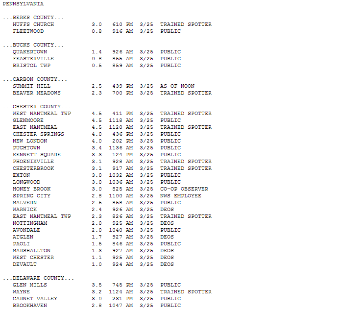
Well, the snowstorm that wasn't ended up turning into the snowstorm that was. After the low pressure system stayed to our south and didn't give our area much precipitation, except for the shore points, it moved offshore and drifted northeastward, only to stall. It was due to this stalling that snow bands were able to wrap around the low and come into New Jersey and Philadelphia from the northeast. This was actually modeled to happen, except to a lesser extent as accumulations ended up at least doubling or tripling predictions in a lot of places. Here are snow accumulation totals from southeast Pennsylvania and South/Central New Jersey from the National Weather Service...note that a lot of these are from the morning before the snow ended, as the times of the measurements are listed next to each town:


Snow Total Prediction
Before I get to a very nice weekend forecast for the area, I want to explain how I come up with predicted snow totals and why snow accumulation can be so hard to predict. Models like the EURO, GFS, and NAM all have runs where precipitation amounts are outputs that are displayed on a map using different colors for different ranges of values. This output of precipitation values is called QPF, or quantitative precipitation forecast, which is the amount of liquid water precipitation that an area is projected to receive.
Once you get the QPF, you use a snow conversion table where liquid water amount, in inches, can be converted to snow amount, in inches. However, this is dependent on air temperature. The higher the temperature, the denser the snow, and the more it will compact together on the surface, causing a smaller snow accumulation than at colder temperatures. Conversely, the colder the temperature, the fluffier the snow, and the accumulation on the ground will be greater because the snow pack on the ground is less dense and compacted. Heavy, wet snow is good for snowballs, and fluffy snow is easier to shovel but not good for snowball-making. Here is a liquid water to snow ratio chart:
This is not the end of predicting snow accumulation, though. Several factors go into predicting totals. First, you need to know the QPF and liquid to snow ratio, along with the air temperature during snowfall. Second, you need to know where the rain/snow line will set up and move during the storm, as rain, sleet, and freezing rain dampen snow accumulations quickly. Third, you must know the ground temperatures, because if they are above-freezing, then it will take heavy snowfall or take time for cold air to cool the surface and get snow to stick to the ground. Fourth, the track of the storm is quite an obvious one that you must know. Then, finally, the set up of heavy snow bands within the snowstorm can cause 'jackpot' areas of localized, heavier accumulations relative to surrounding areas. These are main factors in predicting snow accumulations, and some of these caused problems with forecasting Wednesday's storm.
5-Day Forecast
Finally, we get to the forecast for the next week...After a messy and cold couple of days, we'll be rewarded with a sunny weekend for Saturday and Sunday, with highs in the mid to upper-50's. On Monday, clouds will move in, accompanied by a high of around 60. Showers on Tuesday, modeled to bring around a quarter of an inch of rain, with highs in the mid-50's. Then, it will clear out for Wednesday, leaving behind a nice day with highs in the lower-50's.
Thursday, March 7, 2013
Yet Another Snowfall Disappointment
In a winter full of disappointment for snow in New Jersey and Philadelphia, we have yet another bust for snow, or at least as much of a bust as you can have when there was so much uncertainty. Contrary to the models and what was expected, the storm and main bulk of precipitation stayed south and moved east, rather than northeast. This meant that a constant onshore, warm flow kept any precipitation as rain until late last night when the storm finally moved northeastward and rain showers changed to snow showers. By the time this happened, it was too late for any snow accumulations, and we woke up to some snow showers and flurries scattered around our area.


I believe that Cecily Tynan, of 6 ABC, summed up the thoughts of all meteorologists yesterday in her Facebook post about frustrations with forecasting this storm:
"Ok, I am waving the white flag & throwing out any snow maps completely! The track of this storm (more south and moving east , not northeast) is a RAIN and WIND storm, not a snowstorm. It is not out of the question that a few areas could see a BRIEF changeover to snow, but we are quickly running out of time for this to happen. Man, this has been a headache of a storm since last week! Bring on spring. I am done with this frustrating winter!"
If you want to see how tough it was to forecast this storm and visualize the uncertainty among news stations in the northeast, here is a photo that somebody posted of snow total maps on the Rutgers Meteorology Facebook group...
Although snowfall totals busted, the other aspects of this storm that were forecasted came to fruition. Coastal flooding was a big problem along the shore points of NJ, especially from pictures I saw of Wildwood and many other photos that I saw of the ocean making its way up toward the boardwalks of several towns. Furthermore, winds were also a huge issue all across our area, with the most impressive wind gusts naturally coming from the coast. Here are some of the highest wind gusts recorded during the storm:
Harvey Cedars-64mph
Sea Girt-61mph
Atlantic City Marina-60mph
West Cape May-56mph
Philadelphia-46mph
Flooding Pictures from the "Jersey Shore Hurricane News" Facebook page:
Long Beach Island
Cape May County
Ocean City
North Wildwood
The system will still affect our area today and into tomorrow, as some bands wrap around the low off the coast, bringing some snow and rain showers throughout the day and overnight tonight. Any accumulations would be very light, the best chance for seeing snow on the ground in anyway would be as you head north in New Jersey. The good news, though, is that this weekend is going to be beautiful with plenty of sunshine and highs in the upper 50's!
Subscribe to:
Comments (Atom)