5-Day Forecast
Saturday: Sunny; highs around 60°
Sunday: Clouds and sun; showers late in the day, up to a quarter of an inch; highs around 60°
Monday: Partly cloudy; highs in the lower-60's
Tuesday: Clouds and sun; highs in the upper-40's
Wednesday: Partly cloudy; highs around 50°
Friday, March 29, 2013

Tuesday, March 26, 2013
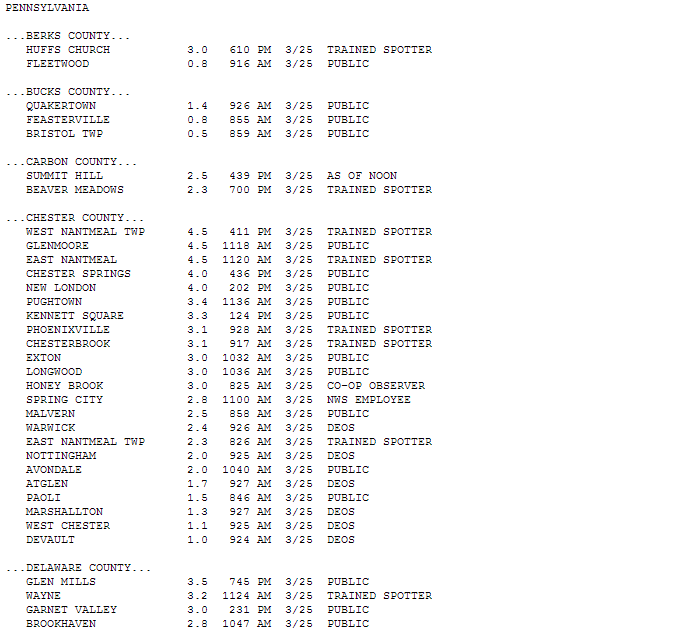
Snow Totals from the 3/25 Snowfall
These are snow totals for the snowfall on 3/25/13 from the Mount Holly National Weather Service website...


Sunday, March 24, 2013
Small Update to Snow Map
Here is the small update to my map with the chances for more snowfall in South Jersey and Philadelphia...


5-Day Forecast and 3/24-3/25 Snowstorm Threat
5-Day Forecast
Sunday: partly cloudy with rain/snow showers late; highs in the upper-40's
Monday: rain/snow, windy; highs in the mid to upper-30's
Tuesday: storm clears out, turning to sun and clouds; highs in the mid-40's
Wednesday: partly cloudy; highs in the upper-40's
Thursday: partly cloudy; highs around 50°
Snowstorm Threat
Well, the GFS was right from my post several days ago...as of right now, all the main models agree on our area receiving at least a light snowfall event. A low from the Midwest and one from the east coast will move through the area and phase, or merge, off the coast and intensify. The timing for this would be an arrival late on Sunday night and an exit late Monday into Tuesday morning. Late Sunday night will bring snow and rain showers, which will persist into Monday when it will turn to snow with snow showers tapering off west to east late Monday or early Tuesday morning. With temperatures being so close to freezing and above, rain and sleet could mix in or change over throughout the day.
As with any wintry event in March, there is great uncertainty and skepticism with snowfall, and this storm is no different, as temperatures are warmer at the surface and chances for a bust in snowfall are higher than in the winter. Most accumulation would be on grassy surfaces with temperatures on paved surfaces being too high to support much in the way of snow accumulation. There is also the possibility of this storm throwing snow bands back into the area after it is supposed to exit, just as the last storm in early-March did and gave NJ a decent amount of unexpected snow, just as a heads up.
The coast will probably not see much of accumulating snow due to temperatures being too high with an onshore flow and rain/mixing, keeping any accumulation minimal, most likely. The further west you go in South Jersey, the best chances for higher accumulations. Models give the Philadelphia/South Jersey area around one inch of precipitation, but it is almost impossible to predict how much of that will attribute to accumulated snowfall until the storm is in progress, depending on ground temperatures, how much snow melts away on impact, and how much snow actually falls during the storm.
Finally, for snow totals, most sources mainly give a couple inches to our area, but the possibility of no accumulation is, of course, there this late in March. The GFS and EURO each give our area a couple inches of snow. The NAM hammers us with a major snowstorm and gives us up to a foot of snow, but that is wishful thinking. Right now, I believe that non-coastal New Jersey and Philadelphia will see accumulating snow but just some small accumulations. I'll post a few snow total forecasts, then give my map...
NAM

Credit: http://www.americanwx.com/raleighwx/models.html
GFS

Credit: http://www.americanwx.com/raleighwx/models.html
My Snow Map

Sunday: partly cloudy with rain/snow showers late; highs in the upper-40's
Monday: rain/snow, windy; highs in the mid to upper-30's
Tuesday: storm clears out, turning to sun and clouds; highs in the mid-40's
Wednesday: partly cloudy; highs in the upper-40's
Thursday: partly cloudy; highs around 50°
Snowstorm Threat
Well, the GFS was right from my post several days ago...as of right now, all the main models agree on our area receiving at least a light snowfall event. A low from the Midwest and one from the east coast will move through the area and phase, or merge, off the coast and intensify. The timing for this would be an arrival late on Sunday night and an exit late Monday into Tuesday morning. Late Sunday night will bring snow and rain showers, which will persist into Monday when it will turn to snow with snow showers tapering off west to east late Monday or early Tuesday morning. With temperatures being so close to freezing and above, rain and sleet could mix in or change over throughout the day.
As with any wintry event in March, there is great uncertainty and skepticism with snowfall, and this storm is no different, as temperatures are warmer at the surface and chances for a bust in snowfall are higher than in the winter. Most accumulation would be on grassy surfaces with temperatures on paved surfaces being too high to support much in the way of snow accumulation. There is also the possibility of this storm throwing snow bands back into the area after it is supposed to exit, just as the last storm in early-March did and gave NJ a decent amount of unexpected snow, just as a heads up.
The coast will probably not see much of accumulating snow due to temperatures being too high with an onshore flow and rain/mixing, keeping any accumulation minimal, most likely. The further west you go in South Jersey, the best chances for higher accumulations. Models give the Philadelphia/South Jersey area around one inch of precipitation, but it is almost impossible to predict how much of that will attribute to accumulated snowfall until the storm is in progress, depending on ground temperatures, how much snow melts away on impact, and how much snow actually falls during the storm.
Finally, for snow totals, most sources mainly give a couple inches to our area, but the possibility of no accumulation is, of course, there this late in March. The GFS and EURO each give our area a couple inches of snow. The NAM hammers us with a major snowstorm and gives us up to a foot of snow, but that is wishful thinking. Right now, I believe that non-coastal New Jersey and Philadelphia will see accumulating snow but just some small accumulations. I'll post a few snow total forecasts, then give my map...
NAM
Credit: http://www.americanwx.com/raleighwx/models.html
GFS
Credit: http://www.americanwx.com/raleighwx/models.html
My Snow Map

Tuesday, March 19, 2013
5-Day Forecast and Storm Threat Outlook
Here is my forecast for the next five days that will take us to the end of my, and a lot of others', spring break...
Tuesday: lingering showers in the morning give way to sun and clouds in the afternoon, windy; highs around 50°
Wednesday: sunny; highs in the mid-40's
Thursday: chance of flurries and snow showers in the early morning, then partly cloudy; highs around 40°
Friday: partly cloudy; highs in the lower-40's
Saturday: partly cloudy; highs in the mid-40's
Outlook
Spring arrives on March 20th with the vernal equinox, which is only one of two times a year where the sun is directly over the equator. In Philadelphia, and the rest of the region, day is now longer than night, and the time of sunset is pushed back later everyday from here on out into June, which I love! However, after looking at the models, it doesn't seem like spring-like temperatures will be arriving within the next two weeks. Unfortunately, there is no tell-tale sign of higher temperatures, a ridge in the pressure heights map, on the horizon, and it seems like temperatures will not make it past the lower 50's within the next 10 days.
Spring arrives on March 20th with the vernal equinox, which is only one of two times a year where the sun is directly over the equator. In Philadelphia, and the rest of the region, day is now longer than night, and the time of sunset is pushed back later everyday from here on out into June, which I love! However, after looking at the models, it doesn't seem like spring-like temperatures will be arriving within the next two weeks. Unfortunately, there is no tell-tale sign of higher temperatures, a ridge in the pressure heights map, on the horizon, and it seems like temperatures will not make it past the lower 50's within the next 10 days.
Furthermore, looking down the road, I see two storm threats within the next couple of weeks: one on my birthday, March 25th, and the other on April 2nd. The one for March 25th would be a cold, rainstorm as it looks now, if it hits us...maybe if it was a few moths ago, I'd be more enthusiastic for snow, but it's just too warm now, especially on ground surfaces for much in the way of snow to fall and accumulate. The GFS gives our area a direct hit, but the EURO takes the storm a couple hundred miles south along the Virginia/North Carolina border. We'll have to see which model caves in to the other, and it is usually the EURO that wins out.
Also, the latest EURO run stops just short of modeling the April 2nd storm, but it definitely shows a coastal storm developing. The GFS models the storm as giving our area a good dousing of rain, but it, of course, is very far out at 14 days, so I'll just keep an eye on it.
Anyway, enjoy the next several sunny days, and hopefully higher temperatures begin to show up sooner than later!
Tuesday, March 12, 2013
Early Spring Break Outlook and 5-Day Forecast
Spring Break Outlook
With spring break at Rutgers (March 16-24), and many other schools, starting in a couple days, I wanted to post an outlook for what the weather will be like for our days at home. Unfortunately, it doesn't seem like spring break will exactly have spring-like temperatures, but it looks like it will have spring-like precipitation for our area. For the outlook, I used a combination of the GFS and EURO, with a bias toward the EURO, of course, since it is the best weather model, but the GFS goes out further. For reference, the average highs, for mid-March in Philadelphia, are in the lower-50's, and March is Philadelphia's second-wettest month, according to weather.com.
Saturday: showers, about a tenth of an inch of rain; highs in the upper-40's
Sunday: cloudy with some sun; rain and snow showers at night, highs in the lower-40's
Monday: rain, up to an inch of rains; highs in the mid-40's
Tuesday: system exits, showers in the morning; highs in the upper-40's
Wednesday: clouds and sun; highs in the lower 40's
Thursday: showers moving in toward the night; highs in the mid-40's
Friday: rain; highs in the 50's
Saturday: rain; highs in the upper-50's
Sunday: wet weather clears out; highs in the 40's
About the system on Tuesday...a few days ago, the euro was modeling it as a major snowstorm for our area and the rest of the northeast. That is no longer true. The possibility is not completely gone, but a bunch of factors work against a high-accumulation snowstorm in March due to the high sun angle and warmer ground surfaces. Furthermore, the GFS never jumped on-board with the euro for a snowstorm, and the euro has now modeled a mainly rainstorm for the past few runs, now. It is still around a week away, so anything can still happen, though. As of now, it looks like a lot of rain for Monday/Tuesday.
5-Day Forecast
Thursday: partly cloudy, windy; highs around 40
Friday: mostly cloudy; highs in the mid-40's
Saturday: showers, around a tenth of an inch of rain; highs in the upper 40's
Sunday: clouds with some sun, giving way to snow and rain showers toward nightfall; highs in the lower-40's
Monday: rain, up to an inch; highs in the mid-40's
With spring break at Rutgers (March 16-24), and many other schools, starting in a couple days, I wanted to post an outlook for what the weather will be like for our days at home. Unfortunately, it doesn't seem like spring break will exactly have spring-like temperatures, but it looks like it will have spring-like precipitation for our area. For the outlook, I used a combination of the GFS and EURO, with a bias toward the EURO, of course, since it is the best weather model, but the GFS goes out further. For reference, the average highs, for mid-March in Philadelphia, are in the lower-50's, and March is Philadelphia's second-wettest month, according to weather.com.
Saturday: showers, about a tenth of an inch of rain; highs in the upper-40's
Sunday: cloudy with some sun; rain and snow showers at night, highs in the lower-40's
Monday: rain, up to an inch of rains; highs in the mid-40's
Tuesday: system exits, showers in the morning; highs in the upper-40's
Wednesday: clouds and sun; highs in the lower 40's
Thursday: showers moving in toward the night; highs in the mid-40's
Friday: rain; highs in the 50's
Saturday: rain; highs in the upper-50's
Sunday: wet weather clears out; highs in the 40's
About the system on Tuesday...a few days ago, the euro was modeling it as a major snowstorm for our area and the rest of the northeast. That is no longer true. The possibility is not completely gone, but a bunch of factors work against a high-accumulation snowstorm in March due to the high sun angle and warmer ground surfaces. Furthermore, the GFS never jumped on-board with the euro for a snowstorm, and the euro has now modeled a mainly rainstorm for the past few runs, now. It is still around a week away, so anything can still happen, though. As of now, it looks like a lot of rain for Monday/Tuesday.
5-Day Forecast
Thursday: partly cloudy, windy; highs around 40
Friday: mostly cloudy; highs in the mid-40's
Saturday: showers, around a tenth of an inch of rain; highs in the upper 40's
Sunday: clouds with some sun, giving way to snow and rain showers toward nightfall; highs in the lower-40's
Monday: rain, up to an inch; highs in the mid-40's
Friday, March 8, 2013
3/7-3/8 Snow Totals and Upcoming Forecast
Storm Snow Totals


Well, the snowstorm that wasn't ended up turning into the snowstorm that was. After the low pressure system stayed to our south and didn't give our area much precipitation, except for the shore points, it moved offshore and drifted northeastward, only to stall. It was due to this stalling that snow bands were able to wrap around the low and come into New Jersey and Philadelphia from the northeast. This was actually modeled to happen, except to a lesser extent as accumulations ended up at least doubling or tripling predictions in a lot of places. Here are snow accumulation totals from southeast Pennsylvania and South/Central New Jersey from the National Weather Service...note that a lot of these are from the morning before the snow ended, as the times of the measurements are listed next to each town:


Snow Total Prediction
Before I get to a very nice weekend forecast for the area, I want to explain how I come up with predicted snow totals and why snow accumulation can be so hard to predict. Models like the EURO, GFS, and NAM all have runs where precipitation amounts are outputs that are displayed on a map using different colors for different ranges of values. This output of precipitation values is called QPF, or quantitative precipitation forecast, which is the amount of liquid water precipitation that an area is projected to receive.
Once you get the QPF, you use a snow conversion table where liquid water amount, in inches, can be converted to snow amount, in inches. However, this is dependent on air temperature. The higher the temperature, the denser the snow, and the more it will compact together on the surface, causing a smaller snow accumulation than at colder temperatures. Conversely, the colder the temperature, the fluffier the snow, and the accumulation on the ground will be greater because the snow pack on the ground is less dense and compacted. Heavy, wet snow is good for snowballs, and fluffy snow is easier to shovel but not good for snowball-making. Here is a liquid water to snow ratio chart:
This is not the end of predicting snow accumulation, though. Several factors go into predicting totals. First, you need to know the QPF and liquid to snow ratio, along with the air temperature during snowfall. Second, you need to know where the rain/snow line will set up and move during the storm, as rain, sleet, and freezing rain dampen snow accumulations quickly. Third, you must know the ground temperatures, because if they are above-freezing, then it will take heavy snowfall or take time for cold air to cool the surface and get snow to stick to the ground. Fourth, the track of the storm is quite an obvious one that you must know. Then, finally, the set up of heavy snow bands within the snowstorm can cause 'jackpot' areas of localized, heavier accumulations relative to surrounding areas. These are main factors in predicting snow accumulations, and some of these caused problems with forecasting Wednesday's storm.
5-Day Forecast
Finally, we get to the forecast for the next week...After a messy and cold couple of days, we'll be rewarded with a sunny weekend for Saturday and Sunday, with highs in the mid to upper-50's. On Monday, clouds will move in, accompanied by a high of around 60. Showers on Tuesday, modeled to bring around a quarter of an inch of rain, with highs in the mid-50's. Then, it will clear out for Wednesday, leaving behind a nice day with highs in the lower-50's.
Subscribe to:
Posts (Atom)