Thursday, December 7, 2017

First Snowfall of the Season Saturday

  It may not technically be winter yet (December 21st), but we're in for our first snowfall on Saturday.  Tuesday night's strong cold frontal passage has set us up for an extended stay of wintry, polar air.  This weekend, we'll see highs in the 30's and near 40° under our cold air mass, and this is one ingredient for the upcoming storm.

  Tuesday night's cold front is currently parked off the coast, and it'll act as a track for a low pressure system to ride along on Saturday.  A favorable setup in the upper atmosphere will allow for the evolution of the precipitation to build over our region throughout the day backing its way into eastern Pennsylvania.  The start of the snowfall will work from south to north throughout the morning hours with the southern-most portion of South Jersey being affected prior to sunrise, the Philadelphia metro area during the mid-morning (7-10am), and then North Jersey during the late morning/around noon.

  The snow will continue to fall throughout the day on Saturday at a general light to moderate, steady pace before ending from southwest to northeast during the evening.  Thanks to the majority of the snowfall occurring during the daylight hours and likely not falling at a continuous, heavy pace, treated road surfaces will mainly remain wet and slushy while most accumulation is confined to grassy and untreated surfaces. 

  The image below shows a representation of the widespread snowfall across NJ during the afternoon on Saturday from the NAM model.

Saturday Afternoon Radar from 18z NAM model run on 12/7/17 (Courtesy: tropicaltidbits.com)


  Onto my snow map...the immediate coastal, inland area will very likely be the jackpot area with decreasing totals as you move further west and northwest away from the center of the storm.  Immediate areas along the coast could potentially have some mixing issues due to marginal temperatures near the surface which could limit totals (not included on map).


My First Call Snow Map


Saturday, July 29, 2017

Dry, Comfortable Weather Follows Coastal Storm

  Friday night's coastal storm may have been a dud for our area, but it certainly wasn't for Southeast New Jersey where they racked up several inches of rainfall.  Below is a table from the Mt. Holly Office of the National Weather Service.  It shows high rain storm totals from the state's southern-most counties.

Rainfall totals reported to the National Weather Service

  Following the storm, a cool, and more importantly, dry air mass will flow into the region.  This is in the process of moving in, and we'll continue to see these conditions through the first half of next week.  Dew points will drop into the 50's for Sunday and Monday with highs near average into the 80's.

  Sunday will be the best weather day with wall to wall sunshine and highs into the low/mid-80's and no humidity issues.  The image below shows temperatures near 80° tomorrow afternoon on Saturday morning's run of the Hi-Res NAM.

Temperatures at 3pm Sunday afternoon (Courtesy of tropicaltidbits.com)

  Monday won't be much different from Sunday except with a slightly warmer high temperature into the mid- to upper-80's

  Finally, humidity gradually creeps back into the region come Tuesday and Wednesday when highs near 90°.  A cold front looks to approach the area to end the upcoming work week and bring the threat for showers and storms come Thursday/Friday.

Sunday, March 12, 2017

Details on the Pi Day Nor'easter

                Winter Storm Warnings for most of the state have been issued with Blizzard Watches into Northeast New Jersey and High Wind Watches along the coast.  Everything’s coming together for our first and probably last major winter storm threat of the season where a lot of places could actually double their current snowfall totals for the whole season.  For example, I’ve measured 11.5” for the winter at my station in Cinnaminson, and I would not be surprised at all if we approach and/or best that by Tuesday evening.

                Models have been consistently showing this system since the latter half of last week, and it looks like all the ingredients are coming together for it to come to fruition.  We’ll likely see the full platter of weather that comes along with a winter nor’easter in the Northeast: high winds, heavy snow, low visibility, coastal flooding, and beach erosion.

                At this time, the first flakes begin to fly from southwest to northeast between 9pm and midnight on Monday night and quickly pick up in intensity.  We’ll see the heaviest of the snowfall between midnight and 10am on Tuesday morning.  The precipitation should dwindle in intensity and taper off during the afternoon hours. 

                Below is an image of this afternoon’s Hi-Res NAM model run showing a depiction of conditions at 8am on Tuesday morning.

Image courtesy of tropicaltidbits.com

                Though it is more likely for the coast and areas within maybe 20-30 miles of the coast, we could see the rain/snow mixing line approach the I-95 corridor from Wilmington to Trenton.  In areas that change over to sleet/rain, even briefly, snow totals would only likely hit the lower end of forecasted ranges along with eating away at snow that has already fallen.  As of now, it looks like it should stay away from the Philadelphia metro area, but it’s a possibility Tuesday morning if the storm's center tracks too far west and closer to the coast.

                As of now, the heaviest banding of snow is still questionable in exact location but likely occurs somewhere between eastern Pennsylvania and just east of the I-95 corridor.  During the AM hours overnight and into Tuesday morning, we could be looking at snow rates upward of 1-3” per hour which would cause visibilities to drop to a ¼” – ½” mile.  A blizzard is officially defined as a time period of 3 hours or more in which 35mph+ winds cause blowing snow with visibility of ¼” or less, and we could see that in some parts of the state during the storm.

                Speaking of winds, we’ll be looking at upward of 40mph wind gusts inland toward the Philadelphia metro area and gusts to 60mph+ along the coast.  That, as stated earlier, would lead to blowing snow and reduced visibility.  Also, this will be a heavier, wet snow that’ll tend to stick to wires and tree branches, so high winds could lead to the possibility of downed branches and power outages.  Again, this threat increases as you get closer to the shore. 

                Finally, for the coastal towns, we’ll be looking at moderate flooding with constant, high onshore winds on Tuesday morning combined with a high tide.  This wind and wave action will also lead to beach erosion as is a trademark of all major nor’easters.  High winds and coastal flooding/erosion are the two effects of this system with the highest confidence.


                Below is my second call snow map.  I’ve upped totals across the board with a jackpot area in North Jersey where heavy banding and no threat of mixing will have the best chance of occurring.  Then, the I-95 corridor of South/Central Jersey is the secondary jackpot area where we could see some high totals under heavy banding but any mixing of sleet and rain could do a number on snow totals if the rain/snow line makes it that far inland.  Then, totals decrease as you approach the shore due to the higher chances of mixing.

My Second Call Snow Map

Saturday, March 11, 2017

Initial Thoughts on the Pi Day Nor'easter

                It took until March for us to see our first true major winter storm threat, and it’s looking very likely that it’ll come to fruition.  Following a January at 5.5° above average and a February at 8.5° above average, it started to seem like an early spring was here to stay, but it looks like Winter 2017 isn’t over yet like the calendar states.

                This is an early post to just state that a nor’easter is very much possible for late Monday night into Tuesday, and all counties but Cape May County are currently under a Winter Storm Watch.  Being 48+ hours from the start, the exact track of the system is unknown and variations of even 50 miles in track can have great consequences on the rain/snow line and snow totals.  If that rain/snow line comes inland, we could be looking at vast differences in snow totals for areas just a couple dozen miles apart.

                Below is an image of this afternoon’s GFS model run showing inland snow for Tuesday at 7am and some mixing issues along the NJ southern coast.

Image courtesy of tropicaltidbits.com

                This post is just meant to put in the back of your mind that there’s potential for a major snowstorm for early next week and to state the possibilities of what we could expect.  The only real certainties we’d be looking at would be gusty winds and coastal effects like coastal flooding and erosion.  Wind-wise, we’d likely be looking at 30+mph gusts inland and 40+mph gusts along the coast.

                Our uncertainties lie, as stated earlier, in the storm track.  As of now, the only model guidance that has an inland and wetter track is the NAM which is used mainly within 36-48 hours of the event, so it’s still out of its main range of use.  Everything else suggests a track further off the coast which would lead to more or all snow, except for the coast.  It’s also uncertain where the heaviest banding of snow will set up, but it’s likely anywhere from just east of the I-95 corridor to eastern Pennsylvania.

                As for timing, generally speaking we’re looking at the first flakes likely falling after nightfall on Monday night and the bulk of precipitation occurring overnight and into Tuesday morning.  Precipitation would then dwindle in intensity and pull away from southwest to northeast during the PM hours.


                I’ll have an updated post tomorrow with more details and revised snow map.  My current map shows a ‘jackpot’ area in North Jersey where there should be no threat of mixing and better snow ratios.  The second is a strip along the I-95 corridor which is likely the biggest unknown of the system with regard to mixing. 

My First Call Snow Map


Friday, September 2, 2016

Hermine's New Jersey Weekend Impact


  Hurricane Hermine amazingly became the first Florida landfalling hurricane in eleven years and is now on its way up the East Coast this weekend.  New Jersey has already clouded over today with Hermine's outer cloud bands, and the state will start feeling the first real impacts tomorrow (Saturday).  Coastal regions will of course see the biggest efects from Hermine, but depending on its track, inland areas could see a major impact as well.  Below is the National Hurricane Center's projected track for Hermine.  The blue outline is a Tropical Storm Warning from the Central Jersey Coast through Georgia.

Forecasted Track for Hermine from the NHC

  Tomorrow, New Jersey will start experiencing the first effects from Hermine as winds start picking up across the region.  We'll see mostly cloudy skies near the Philadelphia metro area while the shore could see its first outer rain bands from the cyclone.  Winds will increase throughout the day as scattered areas of rain threaten inland portions of the state.  After nightfall, these areas could see winds nearing 30mph+ while the coast sees tropical storm force winds (40-60mph+).  Below is a map of probability for tropical storm force winds (39mph+), showing a 50-70% chance across New Jersey.

Probability of Tropical Storm Force Winds from the NHC

  The worst of Hermine will show itself on Sunday and Monday as the system stalls off the coast due to high pressure to the northeast and slowly backs its way toward the coast in all likelihood.  This will lead to dangerous winds working more closely inland.  On top of this, coastal communities will potentially experience major coastal flooding, dangerous wave action, and severe beach erosion.  If this system tracks closer to the coast, as models are showing, areas closer to Philadelphia would likely experience winds gusting to tropical storm strength and periods of rainfall, heavy at times.

  As Tuesday comes around, it looks like Hermine will very slowly move away north and eastward, but breezy/windy conditions will likely remain, especially along the coast.  At this time though, there is uncertainty on how long the cyclone persists just off the coast.

Below would be the potential impacts if Hermine moves as modeled:
-Heavy rainfall (more along the coast with 4-6"...upward of 1-2" inland)
-High winds (Tropical Storm force along the coast...upward of 30mph+ inland)
-Severe beach erosion
-Coastal flooding
-Rough and high seas (modeled wave heights as high as 25-30 feet offshore)
-Power Outages

Reminders:
-Regardless if Hermine becomes a "Post Tropical Storm", it will have the same impact as a tropical storm!
-If it tracks even closer to the coast, coastal impacts would be even more devastating, and inland areas would receive more rainfall and higher winds
-If the system shifts eastward away from shore, inland areas will see minimal rainfall and breezy conditions while coastal areas would still see strong impacts
-Weekend plans for the shore should be re-considered if they haven't already

Thursday, January 21, 2016

Mid-Atlantic Blizzard 24 Hours Away

    Blizzard Watches are now posted from Philadelphia to New York City (likely to become warnings for most by tomorrow), while Blizzard Warnings encompass large areas of Maryland and northern Virginia.  We're now roughly 24 hours from go-time in South Jersey, where the first flakes begin falling toward midnight tomorrow night.  The storm likely lasts for around 24-30 hours across the area and will bring a combination of wet and heavy snow, high winds, and coastal flooding/erosion (to the coast).  Below is a general depiction of the storm, from this afternoon's GFS, off of the Virginia coast, as it throws heavy snow bands and winds into New Jersey for the first half of Saturday.

This afternoon's GFS shows possible blizzard conditions for the first half of Saturday (tropicaltidbits.com)


Timing
Start time: 9pm through midnight from south to north across South Jersey
Heaviest: Overnight hours through Saturday afternoon (snowfall rates of 1-3" per hour likely); thundersnow is also a possibility, so keep an ear out for it!
End time: Still a bit uncertain, but snow looks to generally fizzle out late Saturday night

Impacts
    Overall, not much has changed in general since my last post in regard to the overview of the storm, so I'll just talk about the general impacts of this weekend's nor'easter:
-We'll see a heavy, wet snow out of this system, which will be tough to shovel and also weigh down on tree limbs, power lines, etc.
-Winds will be another major threat, as winds likely gust inland to 40-50 mph (20-30 mph sustained) and gust to 60+ mph along the coast
-The combination of heavy/wet snow and wind (possible blizzard conditions) could cause power outages across the state
-Very strong onshore winds, high tides, and a full moon will all combine to produce major coastal flooding which could devastate beaches and coastal communities

Snow Map
    There are still question marks in regard to snow totals despite my map not changing much since my first call.  The shore still likely sees less due to the threat of some mixing issues Saturday morning/early afternoon due to the strong onshore flow from the ocean.  As of now, the 'jackpot' area looks to be a strip of the state from Southwest Jersey through Central Jersey.  North Jersey, at this time, is on the border of a strong gradient between light accumulations and being in on plow-able snow.  Any shift north or south (there have been some very recent trends north) could either put North Jersey at even less snowfall or in on the high accumulations shown for the southern half of the state.  I'll have a final update tomorrow if needed!  

My Second Call Snow Map


Wednesday, January 20, 2016

Major Mid-Atlantic Snowstorm Incoming

    We're now roughly 48 hours away from go-time in New Jersey with the impending winter storm that has been talked about for days now.  Models have shown remarkable consistency with this storm for several days now, and as its energy begins its descent into the Southeast, they continue to show a major, even possibly historic, Mid-Atlantic nor'easter for the weekend.  The National Weather Service in Baltimore posted Winter Storm and Blizzard Watches earlier all across Maryland and northern Virginia, and the Mount Holly office followed with their own group of Winter Storm Watches for our area.  I wouldn't be surprised if portions of New Jersey saw Blizzard Watches/Warnings as well over the next 48 hours.  Below is a glimpse at what the GFS depicts as our storm on Saturday.

GFS model run depicting general conditions Saturday midday (tropicaltidbits.com)

Overview
    As stated in my post yesterday, energy that worked its way into the Pacific Northwest last night is currently diving south through the Plains states.  The system will then round toward the east as it descends into the Southeast.  Then it move northeast and exits the east coast around the Outer Banks of North Carolina Friday night.  During this time, the low pressure system will strengthen, bringing an onslaught of moisture (mainly in the form of snow) and high winds to the Mid-Atlantic, with the bulls-eye looking to set up over Maryland and northern Virginia.

GFS model run showing high winds across coastal and southern NJ Saturday (tropicaltidbits.com)

Impacts and Estimated Timing
    We'll likely start seeing the first flakes fly in New Jersey from south to north after 7pm on Friday evening.  Snow will quickly become heavier overnight and into Saturday afternoon, which is the time period where we likely see the heaviest snowfall rates and even the possibility of thundersnow.  Though I believe areas toward Philadelphia remain all snow for the storm, the mixing line will have to be watched, particularly on Saturday morning.  As the low continues to approach offshore, winds will reach a peak intensity, with inland areas seeing 20-35 mph sustained winds and gusts to 40-50 mph, while coastal areas likely see gusts of strong tropical storm strength (upward of 60+ mph).  It then looks like snow begins to fizzle out late Saturday or early Sunday morning.

    The snowfall with this system is going to be of the wet variety, which is good for snowballs but bad for shoveling.  This, combined with high winds, will cause the risk of power outages, especially for areas closer to the shore where winds will be at a maximum.  The wind and heavy snow combination with this storm is why I wouldn't be surprised if we saw Blizzard Watches/Warnings posted at some point.  Furthermore, for coastal areas, the combination of strong onshore winds, high tides, and a full moon will likely cause major coastal flooding and beach erosion.  This is a part of the storm that has been relatively unmentioned, and some spots are even forecasted to see tides rival, or possibly exceed, those seen during Hurricane Sandy!

First Call Snow Map
    Finally, at this time, the stripe of highest snow amounts looks to run from Southwest Jersey through Central Jersey, where we could see upward of 12-18" of snowfall.  Along the coast in South Jersey, things are more questionable due to the possibility of sleet and rain mixing in, so I left that area lower for now at 6-12" (higher if it remains all snow).  As you approach North Jersey, amounts likely lower as you move away from where the heaviest bands of snow look to set up.  Then, there will likely be a sharp cutoff in heavy snow amounts to lighter accumulations along the Northwest Jersey/New York border.  Below is my first call for this weekend's snowstorm, and I'll post an updated map and blog with any new details tomorrow!

My First Call Snow Map


Tuesday, January 19, 2016

Potential for Major Winter Storm to End Week

    After a relatively snow-less winter thus far, snow lovers look like they will finally see their first big break of the season as a potentially major winter storm for New Jersey threatens for the end of the week.  The energy that will be the cause of this system is currently moving onshore in the Pacific Northwest and will begin its long, meandering journey across the nation throughout the latter half of the week.  What could potentially result from this nor'easter would be a barrage of snow, winds, coastal flooding, beach erosion, and a spike in bread and milk sales.

Overview
    Essentially, the low pressure system entering the northwest, and its associated energy, will ride over a ridge in the western half of the US.  It will then proceed to then dig toward the south across the Plains and enter the Southeast.  From there, our system will really begin to strengthen and where it heads from that point will determine our storm potential.  We are now now around 72 hours away from go-time, and models will now begin to get a better hold on the system as they can now "see" it better with the energy now moving over land.  Below is a basic overview of the path that the storm will likely take, but its exit along the East Coast will really help to determine our exact weather outcome for Friday/Saturday.

Rough estimated path that the storm take throughout the week with an unknown exit in the east

Where and When?
    Right now, the timing of this system has been fairly consistent with a start during the PM hours on Friday and ending Saturday night, so we're talking upward of a 24-30 hour storm.  However, the real uncertainty, as is in all winter storm forecasting, is narrowing down the exact track.  This is absolutely crucial to determine who sees mixing if at all, where the heaviest snow sets up, where there will be a sharp cutoff in snow totals, etc.  At this time, an exit off the coast between the Delmarva peninsula and the Outer Banks of North Carolina looks to be the best chance at this point.  However, such a large spread is what makes forecasting snow totals so variable at this time frame.

This afternoon;s GFS model run shows the storm for the first half of Saturday (tropicaltidbits.com)
Impacts
    This storm will likely have an impact on communities from North Carolina up through New England and everywhere in between along the I-95 corridor.  The heaviest stripe of heavy snow currently looks to lie in a region from Virginia into Maryland and then through Southeast Pennsylvania and New Jersey.  Here, we could "POTENTIALLY" see snowfall totals upward of a foot and/or higher (which has been modeled for days now).  High winds will accompany this snowfall as the low strengthens near the region, and we may even have to bring out the "B word" (blizzard) if things line up correctly in some areas.

    Finally, impacts that may not get as much 'glamour' and conversation as snowfall will greatly affect the coastal areas of New Jersey and the rest of the Mid-Atlantic coast.  There, we will likely see long durations of tropical storm force winds of 50+ mph coming ashore.  When you pair this up with a full moon and high tides, we will be looking at major coastal flooding and extensive damage to beaches.  The shore areas will carry that dual threat of water and snow while areas inland prepare for possibly heavy snow accumulations.

    My first call snow map will likely be out tomorrow evening, along with updates and more details about what we may expect to end the week!

Monday, January 11, 2016

Clipper to Bring Snow/Rain Showers Tuesday

Overview
    Tomorrow, a weak clipper will dive out of the Upper Midwest and cut through the Great Lakes/Northeast to our north throughout the day.  Ahead of it, highs will actually warm decently into the low- to mid-40's, with increasing clouds during the morning and early afternoon.  As the energy from this system approaches the areas, we'll see the threat of some rain and snow showers to spark up across the region.

Timing and What?    
    The chance of precipitation is most likely between 3pm and 11pm Tuesday.  The late afternoon before sunset will be the best threat for a rain/snow mix, but as the cold air rushes in around sunset, any precipitation falling likely comes down in the form of a flurry/snow shower or even a heavier squall in some spots.  Though pavement accumulation isn't likely due to the 'warmth' during the day (and even a little bit of possible sunshine), unpaved surfaces will cool off much more quickly and give the best chance of any accumulation with the scattered precipitation.

Where and How Much?
    The best accumulation threat is the further north and west you go, where the most energy and colder air will be.  Therefore, North Jersey holds the best chance of a coating to 1" on all surfaces (even 1"+ in heavier squalls).  Then, heading into Central and South Jersey, the showers will be a bit more scattered, leaving a trace to coating threat, with even upward of a few tenths of an inch.  Though, the best possibilities of this the further north you are.  These accumulations would likely be more confined to grassy and unpaved surfaces due to slightly warmer temperatures.  Finally, the extreme southern parts of the state will see the best chance of just a trace of snow, likely not accumulating on average with a better chance of liquid precipitation.  

Reminder: A "trace" is anywhere from one flake of snow to less than 0.1"


My 1/12/16 Snow Map


Saturday, January 9, 2016

Winter's Back! ...After This Weekend Ends

    Winter is finally back to start 2016, following a December that obliterated records due to warm temperatures!  The atmospheric pattern has finally become more favorable for cold and winter storm potential, so I hope that you didn't think it'd be gone for good, especially since spring doesn't start for more than two months.  However, through tomorrow, it will actually feel a bit like spring due to a combination of mild temperatures and rain.  Following tomorrow though, cold air and snowflakes are fair game.

    As a decent low pressure system pushes north through the Ohio Valley tomorrow, a southerly flow out ahead of it will provide us with highs of ~25° above average, possibly breaking records.  Philadelphia's record high tomorrow is just 63°, and we'll likely reach into the mid-60's.  Accompanying this warmth will be a nice shot of rain, which will mainly begin after midnight tonight and last through mid-day tomorrow, with periods of steady rain (moderate to heavy at times).  In total, we'll likely see rainfall totals of around 1" through tomorrow evening.  Winds will also be a further impact, as we'll see them sustained at 10-25 mph through tomorrow night, with gusts to 40 mph possible.  Below is simulated radar for 4am early Sunday morning:


12z NAM simulated radar at 4am Sunday morning (tropicaltidbits.com)

    One possible concern would be for Sunday night/early Monday morning, when lows drop below freezing, which would provide for any remaining wet spots to freeze over following tomorrow's rainfall.  In addition, behind tomorrow's system, a trough will dive into the Northeast, bringing winter-like cold back to the region.  Highs will regress back into the 30's/low-40's throughout the week, with lows into the teens/20's.  Breezy conditions will continue Monday through Thursday, which will help make it feel even colder than it already is.

    Finally, for now, we have a very minor snow threat to talk about!  A clipper will quickly dive out of Canada on Tuesday, bringing the possibility of flurries and scattered snow showers after the late afternoon and into the night.  Though it's nothing major and would likely do nothing more than coat the ground at worst, it would be a very welcome sign to snow-starved lovers of snowflakes (better idea as Tuesday gets closer of course).  Below, I'm even attaching this morning's NAM model run, showing some scattered snow showers toward sunset on Tuesday for our area:

12z NAM showing scattered snow showers for 4pm Tuesday (tropicaltidbits.com)


Sunday, December 20, 2015

Warmth and Showers Leading Up to Christmas

    Winter officially begins on December 21st, but it will feel a lot more like October over the next several days, as temperatures increase throughout the week, culminating in what will likely be record-shattering warmth on Christmas Eve.  Through December 19th, Philadelphia is 11.2° above average for the month, and above average temperatures will generally be the main story through the end of the year.  The period of December 10-18th saw temperatures of 11-24° above average itself, and no day this month has been below average thus far.  Below is my forecast for our holiday week, with still some uncertainty for rainfall totals on Wednesday and temperatures for Christmas Day.

Monday
  As a weak cold front approaches from the west, it will dissipate and 'likely' leave us dry.  We'll see a gradual increase in clouds through the day, with partly/mostly cloudy conditions in general.  Our week of mild temperatures will begin with a high of 55-60°.

Tuesday
  An upper-level disturbance moves through the Northeast and brings clouds and the threat of showers for the morning/afternoon, with any precipitation likely ending by sunset.  We'll likely see upward of a tenth of an inch or so, with a high of around 60°.

Wednesday
  A frontal boundary approaches from the west, a warm front will move through the area, and precipitation will overtake the area.  Periods of showers and rain will fall throughout the day as a low pressure system strengthens over the Great Lakes, providing for windy conditions as well as rain.  It appears at this time, with upward of 0.50-1.00" possible and a high in the mid-60's (Philadelphia's record high is 66°).  Below is modeled radar for 4pm on Wednesday:

Modeled radar from the NAM for 4pm on 12/23 (Image courtesy of TropicalTidbits.com)

Christmas Eve
  Any lingering showers end by the afternoon, and high pressure from the west should begin to dry things out with some clearing.  We'll likely remain breezy, as temperatures soar to 70°+ (current trends are for the low- to mid-70's!).  The record high for Philadelphia is 64°, and it's looking like this record will be shattered.  Below is the GFS MOS Data that shows modeled record temperatures for Thursday:


Christmas Day
  High pressure will continue to build in to provide for a dry and mild holiday, with temperatures still uncertain but likely nearing 60°, but it really depends on the timing of our frontal passage.  
  

Friday, December 11, 2015

Record Warmth This Weekend

    The past month and a half have certainly had plenty of warmth, as winter-haters rejoice and snow-lovers weep.  November was 5.6° above average in Philadelphia, and so far through December 10th, the city is currently 7.0° warmer than average.  Coincidentally, that number will increase through the weekend thanks to temperatures that will likely set records.  The record high for Saturday & Sunday in the Philadelphia area is 65°, with Monday's being 69°.

    Ahead of an approaching system from the west, a ridge will build in across the Northeast for the weekend, allowing for warm air and moisture to build into the region.  The process that will help cause these abnormal temperatures, called warm-air advection, is the transport of warmer air by the flow of the atmosphere.  In our region, this usually happens with a southerly flow, which brings warmth and moisture from the Gulf Coast, which is what we'll be seeing through Monday.

    For our Saturday, morning fog will give way to a mostly to partly sunny sky, with calm, dry conditions and a high in the mid-60's.  Sunday will then be much of the same with even warmer highs into the upper-60's, and some places could even threaten the 70°-mark!  Below is GFS data showing highs well into the 60's and approaching the 70's when our average high is only in the mid-40's.

GFS MOS data from Friday showing record warmth this weekend!

    However, all good things must come to an end, as clouds will increase on Monday with that cold front approaching from the west.  Though the region will continue to see highs well into the 60's, showers will be the story for the PM hours, with upward of a half an inch of rain possible at this time.  On top of the warm temperatures and rain threat, windy conditions will be in play due to the pressure difference between the strong low pressure over the Great Lakes and high pressure off the coast.  Breezy conditions will continue into a beautiful and slightly cooler Tuesday.  Below is the GFS (American) model's look at Monday's rainfall for Monday late afternoon/evening.

Friday afternoon's GFS model run showing Monday's rain threat.  Image courtesy of TropicalTidbits.com

Saturday, October 17, 2015

Cinnaminson Day Forecast

    Heading out to Cinnaminson Day on Sunday?  Here's a detailed forecast for the chilly day:

Morning (Through Noon)
    Temperatures early in the morning will be reaching a low in the mid-30's, with some area even approaching the freezing mark.  With high pressure continuing to build in from the west following Friday's cold frontal passage, winds out of the northwest continue to bring colder into the area.  We'll see mostly sunny clouds for the morning hours, with winds beginning to strengthen toward mid-morning (10-15mph).  Temperatures will increase from the mid-30's around sunrise into the 40's by late morning,

Afternoon (Noon-5pm)
    Temperatures will continue to climb to a high of around 50° for the afternoon hours, with clouds increasing to partly sunny skies.  Winds will also be on the increase, with 10-20mph winds and gusts to 30-35mph, which will not help with how chilly it'll feel, even with a good amount of sunshine (it'll feel like the 40's).  Finally, with some upper-level energy passing through the region during the PM hours, there will also be the slightest chance of a shower which can not be ruled out, but it will certainly be mainly dry.

Evening (After 5pm)
    Clouds decrease through sunset as temperatures begin to tumble, as it'll fall back into the 40's by nightfall.  Winds will also fall off through the evening time frame, with mainly clear skies.

Thursday, October 15, 2015

Season's First Cold Blast Incoming

    It looks like we'll be in store for this season's first cold air blast this weekend, as winter-like temperatures overtake the Northeast.  A weak and moisture-starved cold front moves through tomorrow, with high pressure building in behind it.  Ahead of the cold front today, we had relatively warm air, with highs in the 60's, helped out by winds out of the west and southwest.  However, winds shift out of the northwest tomorrow, which generally occurs behind cold fronts, and will bring colder air out of Canada.

    This wind out of the northwest will pull down the colder air out of Canada (called cold-air advection) and will bring temperatures in the 50's during the day and 30's at night for the Philadelphia Metro area.  As you can see from the MOS data below, low temperatures will fall into the lower-40's Friday night, but the truly winter-like air will be in store for us on Saturday and Sunday night.  Clear skies and calm winds are the perfect combination for cooling, and we'll probably only see one of those Saturday night, with mainly clear skies and still a little breezy, leading to lows in the mid- to upper-30's.  Breeziness calms a bit more for Sunday night, which will allow for our lows to approach freezing, so watch early Monday morning for the possibility of some frost.  The typically colder areas, especially to our north and northwest will even fall into the 20's during this time!


GFS MOS Data for Mt. Holly, NJ showing lows in the 30's for this weekend!

    During the daytime, we'll see mostly sunny skies Friday through Monday, with highs decreasing throughout the weekend.  Highs Friday will rise back into the 60's but go downhill from there.  Highs only reach the mid-50's Saturday, with breezy conditions, while Sunday and Monday see highs only reaching into the lower-50's and around 50° throughout the area.  Though we'll see dry conditions likely through Monday, higher elevations and areas of Northwest New Jersey through Central Pennsylvania will have the threat of some snow/rain showers on Sunday, with temperatures allowing for that threat.  This can be seen in the image of the GFS model run below, displaying rain/snow showers across parts of the Northeast on Sunday.  If you hate the cold, don't worry, because temperatures look to rebound next week.

This afternoon's GFS model run showing rain/snow showers Sunday for some areas
Image courtesy of TropicalTidbits.com


Monday, September 28, 2015

Drought Relief With a Rainy Week Ahead

    Dry dry dry...New Jersey has actually been in the midst of a minor drought, with much of the state in the lowest category of "Abnormally Dry" and parts of Northeast New Jersey in a "Moderate Drought", which can be seen in the image below from the "United States Drought Monitor" website.  However, it appears that this is going to take a drastic turn this week as we keep an eye on multiple threats for rain this week.  We'll see the possibility of a whole package of weather for the upcoming week, with rain, cooler temperatures, windy conditions, flooding, and coastal beach erosion all affecting New Jersey by the end of the weekend.

Northeast Drought Conditions as of 9/22/15 (http://droughtmonitor.unl.edu/Home/RegionalDroughtMonitor.aspx?northeast)

    Tomorrow, a low pressure system will approach from the southwest as a cold front moves toward the area, with our last day of warmth (around 80°) and high humidity before it drops off on Wednesday.  The low pressure center will ride along the frontal boundary and begin to being showers after nightfall, though an isolated shower couldn't be ruled out during the day.  The boundary will then stall near our area as it passes through on Wednesday, and periods of showers and moderate to heavy rain will likely fall throughout the overnight hours into the daytime hours.  Depending on exactly how strong this low is and where it sets up, we could be looking at up to 1-2" inches of rainfall through Wednesday night, with areas of higher amounts across the region (especially into Northwest NJ and Central PA).  Below is an image of forecasted rainfall totals through 8pm on Wednesday.

Weather Prediction Center Forecasted Rainfall Amounts Through 8pm Wednesday

    Though the front stalls near our area, we'll be on the cooler side behind it, with temperatures falling into the low- to mid-60's for highs to end the week, with winds beginning to whip up out of the northeast.  A strong high to our north, and developing low pressure to the south, will create a strong pressure gradient to produce 10-25mph sustained winds (higher gusts) off the ocean Thursday and through the weekend (strongest winds along the coast).  This will be a cause for concern along the coast, as strong beach erosion and coastal flooding will likely occur.

   Also, this stalled front will allow for continuous areas of showers to affect the region on Thursday into Friday, with mostly cloudy conditions continuing.   Friday/Saturday will become interesting as the week wraps up, as we watch the track of what will likely become Tropical Storm Joaquin (currently Tropical Depression Eleven).  The National Hurricane Center currently has it forecasted to be off the coast of New Jersey on Saturday (image below), allowing for windy and wet weather to persist into the weekend.  Right now, it looks like a trough over the eastern US and a high to the east will allow for the system to ride along or even make landfall in the Northeast, but a lot can happen between now and then.  Though, by the end of this weekend, some places could be looking at rainfall totals of several inches or more. 

    By the start of next week, it looks like high pressure will provide a rebound to more settled and beautiful weather!

The National Hurricane Center's Current Track for Tropical Depression Eleven


Wednesday, September 9, 2015

Rain and Storms for Thursday

    Summer still has two weeks left, and our recent weather is certainly proving that.  We're coming out of an August that provided for plenty of sun, heat, and humidity with little relief in the way of rainfall.  Consequently, we have had two heat waves in less than two weeks entering September!  The Philadelphia metro area was bone-dry, with less than an inch of precipitation for the whole month of August, 0.98" to be exact.  However, the region will likely see that total and more just within the next 48 hours as a cold front moves through, along with a low pressure system riding along that boundary.

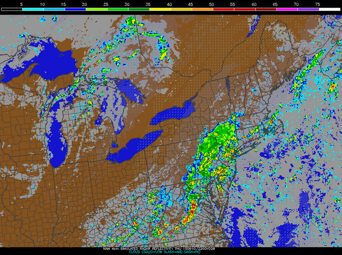
    As the front approaches tonight, a line of widespread showers and storms will begin to affect the area after midnight.  Our current instability in the atmosphere will allow for thunderstorms and periods of heavy rain to occur throughout the overnight hours and during our Thursday.  This will result in a long-lived soaking of the state, which is currently in the beginning stage of a drought, in the category of "Abnormally Dry".  The instability drops off by tomorrow evening, leaving us with periods of just showers and heavier rain, without the storm threat.  Below is a modeled look at radar for tomorrow at 6pm from the afternoon 4km NAM run.

18Z 4km NAM model run (9/9/15)...courtesy of the PSU E-Wall

    Humidity will stay with us tomorrow, but the temperature will plummet compared with the past few days, with a high in the lower-80's.  Along with this drop in temperatures, periods of heavy rain and storms will fall throughout the day and into the evening.  As nightfall approaches, rainfall will likely become less numerous and widespread, with the threat of rain gradually dropping throughout the overnight hours.

    By early Friday morning, we'll just be dealing with the chance of some lingering showers of the scattered variety, as clearing occurs and we see a mix of sun and clouds for the day.  The heat and humidity will be gone, lasting throughout the weekend and into next week.  Regardless, we should be completely dry by the afternoon on Friday but not before the region sees much-needed rainfall.  Total-wise, most will see upward of 1-2"+ of rain, with some locations receiving more under repeated heavy banding of downpours and storms.  Below is modeled precipitation totals from this afternoon's NAM model run for the Northeast through Friday afternoon, with many seeing up to and over 1" and some places seeing 2"+.

18Z NAM model run for precipitation totals through Friday afternoon...courtesy of Tropical Tidbits


Saturday, August 15, 2015

Heat and Humidity Return This Week

    Lately it's almost felt like summer was winding down and fall was right around the corner, as highs dropped to around 80° and into the low- to mid-80's with uncomfortable humidity almost nowhere to be found.  However, that's all changing starting today and for the week ahead as true summer-like conditions ramp back up and soupy air make a return.  Heat is already here to stay, and humid conditions will be on a gradual rise through the beginning of the week, culminating in the threat for scattered showers and storms for the latter half of the week.

   As I said before, high temperatures have already set into the region, but dew points will certainly be on the rise for tomorrow through Tuesday, as shown in the model data below.  We'll continue to see mostly sunny skies dominate the landscape due to a high pressure system over our area.  However, as it slides offshore, flow will come out of the southwest providing for an increase in moisture and retention of heat, so this is where the humidity increase will come from.  Generally speaking, 60-65° starts to feel sticky (tomorrow), 65-69° is uncomfortable (Monday), and 70°+ is oppressive (Tuesday), so we'll be going through all of these stages over the next few days (with highs in the 90's).

GFS MOS Data with dew points highlighted in a red box

    So when will we see rain again?  A June that was 5.65" above normal in rainfall (in Philadelphia) quelled drought concerns, but a below-average July in precipitation has made it seem pretty dry recently (almost in the lowest drought category per The National Drought Mitigation Center).  However, it appears that we could see a showery and stormy end to the week due to an approaching cold front.  Tuesday and Wednesday will see the slight threat for an isolated shower or storm, but those days will more likely than not remain dry, with partly sunny conditions.  This does not quite look to be the case for Thursday and Friday though.

   A low pressure system will move across the Great Lakes/Upper Midwest region on Thursday, and its associated cold front will affect our region to end the work week.  The period from Thursday morning to Friday evening has the highest precipitation threat for the week, with the chance for showers, downpours, and thunderstorms, with breaks of sunshine between.  Below is the GFS model run for this morning displaying Thursday's precipitation to give an idea of the rainfall across the area as the cold front approaches,  As always with being this far out, if this front speeds up, we could be looking at some rain sneaking its way into your Wednesday PM.

12Z GFS model run showing Thursday at 2pm (Image courtesy of Tropical Tidbits)


Friday, July 3, 2015

4th of July Weekend Forecast

Rest of Friday
    The rest of the daytime hours will be beautiful, with highs in the 80's and a mix of  clouds and sun.  Clouds will build through the rest of the day, as a low pressure system approaches the west and brings the threat for showers overnight tonight.

Saturday (4th of July!)
    As a low pressure system approaches the area and moves off just to the south, we'll see the threat for showers throughout the day tomorrow.  The best chance for precipitation looks to be during the morning and early afternoon, with chances for rain dwindling as you head into the evening hours.  Highs will likely remain in the upper-70's, with just enough humidity to feel a little uncomfortable but not bad.

This morning's NAM model run showing simulated radar at 11am tomorrow

Sunday
    High pressure builds back in and provides for plenty of sunshine and comfortable conditions.  Highs will jump back up into the mid-80's, making for a great end to the holiday weekend!

Friday, June 19, 2015

Tropical Storm Bill's Remnants to Bring Weekend Rain

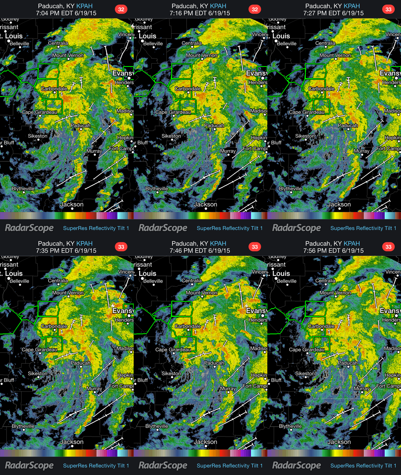
    Tropical Storm Bill made landfall along Texas' Gulf Coast on Tuesday, June 16th, with winds to 60 mph and heavy rain.  Now, less than a week later, our area will be affected by the rainy remnants of that tropical cyclone.  Bill has certainly left its mark on the areas that it has passed through, bringing several inches of rain to portions of Texas and Oklahoma and severe weather (including tornadoes) to the Midwest.  Below is a radar loop of what Tropical Depression Bill looked like this evening over the Missouri/Illinois/Kentucky border area.

Tropical Depression Bill Radar Loop (Gif courtesy of RadarScope)
    So how will these tropical remnants affect our Father's Day Weekend in southern New Jersey?  Well, an unstable atmosphere will allow for scattered showers and thunderstorms to spark up across the region on Saturday during the daytime hours.  However, this is not the main concern.  Bill's area of low pressure will approach and push through Philadelphia and South Jersey late Saturday night and into Sunday morning.  The heaviest of the rainfall and storms look like they will fall after midnight and last into Sunday morning (likely out by 9am-12pm).  The image below shows this afternoon's NAM model run of the simulated radar at 8am on Sunday morning, showing heavy precipitation over the area.

18Z NAM model run's for Sunday morning at 8am (Image courtesy of Tropical Tidbits)
    The whole region is under a Flood Watch due to the potential for a long duration of heavy rainfall over a short amount of time.  Generally-speaking, it looks like we will be looking at upward of 1-3" of rain through overnight hours of Saturday/Sunday and Sunday morning.  Though, isolated locations could see 3"+ of rainfall, as the low pressure center brings a ball of very heavy precipitation into Southeast Pennsylvania and New Jersey. The image below shows a swath of heavy rainfall totals through Sunday evening from Kentucky to South Jersey.

Modeled precipitation totals through 8pm on Sunday evening (Image courtesy of the WPC)
    Finally, it does appear that when the rainfall ends Sunday morning, dry air will quickly pull in behind it to begin to dry things out.  Sunshine will likely make a return for the afternoon and evening (partly cloudy skies), but there will be the threat for scattered PM showers and storms as a low moves off to the north and a front moves through the area.


Sunday, June 14, 2015

Rain and Storms Possible Through Tuesday Night

  It's looking like a rainy/stormy week ahead, with the threat of rain and storms possible each day.  This threat will especially be there for the next few days through Tuesday night (and again to end the week due to a tropical disturbance currently in the Gulf of Mexico).  Anyway, hot temperatures, humid air, and the chance for rain and storms (some have the chance of being severe) will be interspersed with periods more clouds than sun.  This weather is thanks to the set-up that will feature a warm front over the region through Tuesday evening, when a cold front will push through.

Today
  We'll see partly to mostly cloudy skies, with highs in the mid- to upper-80's.  Humidity levels won't be as bad as they will be in the coming days, and it'll be mainly dry throughout the afternoon and early evening.  Toward 7pm and later, we'll be looking at the threat for showers and storms, with periods of rain possible, especially after nightfall and overnight.  The severe threat won't really be there as much as tomorrow and Tuesday though.  The image below shows this morning's NAM model run simulating the radar for tonight at 11pm depicting moderate to heavy rain and storms over the area.

Above: This morning's NAM model run depicting the radar at 11pm tonight (Courtesy of Tropical Tidbits)

Tomorrow and Tuesday
  This will be the time period to really be on the lookout for thunderstorms and severe weather, as the atmosphere will have more instability.  Tomorrow will feature the chance for rain and storms throughout the day, and some storms could be severe, with the main threats being heavy rain and gusty winds.  Otherwise, dry periods will be under mostly cloudy skies, with highs around 90° and heat indices into the mid- to upper-90's (oppressive humidity).

  Tuesday will see much of the same, except with the threat beginning toward mid-day.  Though severe storms are more likely on Monday, the chance for them will remain for Tuesday, with periods of heavy rain and gusty winds being of main concern.  Highs will be 85-90°, with very oppressive humidity.  The cold front then pushes through during the evening.

Overview
  In general, it looks like most areas will be looking at upward of around 1" of rain through Tuesday; however, isolated areas could be looking at more under repeated downpours and storms, which is the norm during the spring and summer months.  The image below shows modeled rainfall totals through Wednesday at 8am and depicts upward of 1-3" across the area during that time frame.  Finally, threats for rainfall and storms will continue throughout the rest of the week, especially as moisture from what could be Tropical Storm Bill has the chance to affect the area toward the end of the work week.  However, tomorrow and Tuesday remain the best chances for severe thunderstorms.

Above: Modeled rainfall totals between today at 8am and Wednesday at 8am (Courtesy of NOAA)