As the front approaches tonight, a line of widespread showers and storms will begin to affect the area after midnight. Our current instability in the atmosphere will allow for thunderstorms and periods of heavy rain to occur throughout the overnight hours and during our Thursday. This will result in a long-lived soaking of the state, which is currently in the beginning stage of a drought, in the category of "Abnormally Dry". The instability drops off by tomorrow evening, leaving us with periods of just showers and heavier rain, without the storm threat. Below is a modeled look at radar for tomorrow at 6pm from the afternoon 4km NAM run.
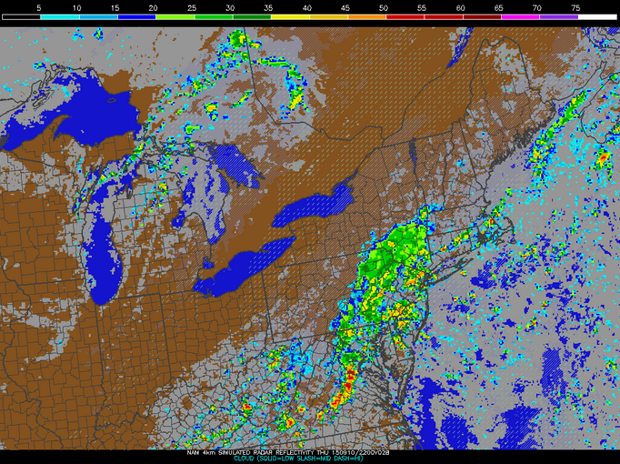 |
| 18Z 4km NAM model run (9/9/15)...courtesy of the PSU E-Wall |
Humidity will stay with us tomorrow, but the temperature will plummet compared with the past few days, with a high in the lower-80's. Along with this drop in temperatures, periods of heavy rain and storms will fall throughout the day and into the evening. As nightfall approaches, rainfall will likely become less numerous and widespread, with the threat of rain gradually dropping throughout the overnight hours.
By early Friday morning, we'll just be dealing with the chance of some lingering showers of the scattered variety, as clearing occurs and we see a mix of sun and clouds for the day. The heat and humidity will be gone, lasting throughout the weekend and into next week. Regardless, we should be completely dry by the afternoon on Friday but not before the region sees much-needed rainfall. Total-wise, most will see upward of 1-2"+ of rain, with some locations receiving more under repeated heavy banding of downpours and storms. Below is modeled precipitation totals from this afternoon's NAM model run for the Northeast through Friday afternoon, with many seeing up to and over 1" and some places seeing 2"+.
 |
| 18Z NAM model run for precipitation totals through Friday afternoon...courtesy of Tropical Tidbits |
No comments:
Post a Comment