It's looking like a rainy/stormy week ahead, with the threat of rain and storms possible each day. This threat will especially be there for the next few days through Tuesday night (and again to end the week due to a tropical disturbance currently in the Gulf of Mexico). Anyway, hot temperatures, humid air, and the chance for rain and storms (some have the chance of being severe) will be interspersed with periods more clouds than sun. This weather is thanks to the set-up that will feature a warm front over the region through Tuesday evening, when a cold front will push through.
Today
We'll see partly to mostly cloudy skies, with highs in the mid- to upper-80's. Humidity levels won't be as bad as they will be in the coming days, and it'll be mainly dry throughout the afternoon and early evening. Toward 7pm and later, we'll be looking at the threat for showers and storms, with periods of rain possible, especially after nightfall and overnight. The severe threat won't really be there as much as tomorrow and Tuesday though. The image below shows this morning's NAM model run simulating the radar for tonight at 11pm depicting moderate to heavy rain and storms over the area.
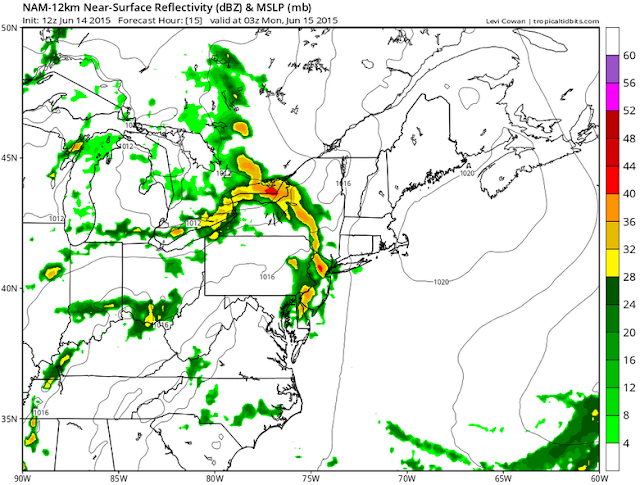 |
Above: This morning's NAM model run depicting the radar at 11pm tonight (Courtesy of Tropical Tidbits)
|
Tomorrow and Tuesday
This will be the time period to really be on the lookout for thunderstorms and severe weather, as the atmosphere will have more instability. Tomorrow will feature the chance for rain and storms throughout the day, and some storms could be severe, with the main threats being heavy rain and gusty winds. Otherwise, dry periods will be under mostly cloudy skies, with highs around 90° and heat indices into the mid- to upper-90's (oppressive humidity).
Tuesday will see much of the same, except with the threat beginning toward mid-day. Though severe storms are more likely on Monday, the chance for them will remain for Tuesday, with periods of heavy rain and gusty winds being of main concern. Highs will be 85-90°, with very oppressive humidity. The cold front then pushes through during the evening.
Overview
In general, it looks like most areas will be looking at upward of around 1" of rain through Tuesday; however, isolated areas could be looking at more under repeated downpours and storms, which is the norm during the spring and summer months. The image below shows modeled rainfall totals through Wednesday at 8am
and depicts upward of 1-3" across the area during that time frame. Finally, threats for rainfall and storms will continue throughout the rest of the week, especially as moisture from what could be Tropical Storm Bill has the chance to affect the area toward the end of the work week. However, tomorrow and Tuesday remain the best chances for severe thunderstorms.
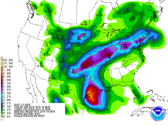 |
| Above: Modeled rainfall totals between today at 8am and Wednesday at 8am (Courtesy of NOAA) |